Showing posts with label glaciers. Show all posts

Sunday, March 16, 2025

New glaciers found in the Japan Alps

A survey by Niigata University and others has confirmed that two more snowfields in the region around Shirouma (2,932m) qualify as "glaciers." The new ice streams bring the total of relic glaciers discovered in the Northern Japan Alps to seven or so – joining the three discovered on Tsurugi and Tateyama in 2012 and two more subsequently found on or around Shirouma.

NHK Shinshu announces the discovery of the new glaciers.

The two newly confirmed glaciers are located under the Kaerazu-zawa and Shakushi-zawa snowfields. The latter can be seen from Hakuba Village at the foot of the Shirouma (“White Horse”) massif. Shirouma is one of Fukada Kyūya’s One Hundred Mountains of Japan.

The view from Hakuba Village.

A snowfield, says NHK (see references below), is defined as a localised area of snow that remains even in the summer. It qualifies as a glacier when it meets certain criteria, such as the ice masses within it moving at a certain speed.

In a survey conducted by Niigata University and others from 2021 to 2022, it was confirmed that an ice mass with a maximum thickness of 43 meters in the Shakushi-zawa snowfield moved up to 26 centimetres in about one month, and an ice mass with a maximum thickness of 29 meters in the Kaerazu-zawa snowfield moved up to 14 centimetres. A paper summarising the survey results will be published in an international scientific journal.

Locations of the Karamatsu-zawa and Kaerazu-sawa snowfields.

There are now four snowfields in Nagano Prefecture that have been confirmed to be glaciers, including the Kakunesato snowfield on Kashimayari (2,889m), another of Fukada’s One Hundred Mountains, and the Karamatsu-zawa snowfield above Hakuba Village.

Researchers on one of the Shirouma snowfields.

As quoted by NHK, Professor Narama Chiyuki of Niigata University, who conducted the survey, said "The impact of global warming on the Japanese Alps has not been fully understood due to a lack of long-term observation data. We believe that the newly discovered glaciers can be used as an indicator of environmental change, and we would like to continue observing them in the future."

References

NHK Shinshū news web, 白馬村の2つの雪渓 新たに「氷河」と確認 新潟大などの調査, 20 January 2025.

Yama to Keikoku magazine, 北ア白馬の2雪渓新たに’氷河’と確認, March 2025 edition.

Tuesday, October 29, 2024

Poetry of the ice

Book review: a Swiss glaciologist celebrates the transient icebergs on a mountain lake and explains why they matter.

All across the Alps, glaciers are slumping into lakes and pools of their own meltwater. A typical example is the little glacier at the top of the Geren Pass, a windy gap in the ridgeline above Switzerland’s Bedretto Valley. A crescent-shaped lake formed at its foot at the start of this century, and has been expanding ever since, eating steadily into the remaining ice-field. 


In November 2020, however, something different happened here. As winter comes early at 2,670 metres, the lake had already frozen over by the 26th of the month. Unfortunately, nobody was watching on or around that day when, probably within a few minutes, huge blocks of the former glacier erupted upwards, smashing their way through the surface ice or rafting it high into the air.

The lake on the Geren Pass in September 2020.
Image by courtesy of Alpine Light & Structure

What had happened? Within a few weeks, a curious researcher, Giovanni Kappenberger, had skied his way up to the pass to find out. Few could be better qualified to do so. As Kappenberger’s family and given names suggest, his life has spanned the very same Italian and German-speaking regions that the Geren Pass links together. He was born in Italian-speaking Lugano in 1948, but studied natural sciences at Zurich’s Federal Institute of Technology (ETH). While working as a meteorologist for the next few decades, he also kept up his interests in glaciology by helping to monitor the mass balance of the Basodino glacier, Ticino’s largest expanse of ice.

The lake after the "evento catastrofico" of November 2020.
Image from Giovanni Kappenberger: Die Eisberge am Gerenpass

Arriving at the Geren Pass, Kappenberger saw a new chaos of giant ice blocks crowded into the small lake. This couldn’t be a normal “calving” from the end of the glacier, as in other lakes. Instead, he deduced that some kind of “evento catastrofico” was responsible.

Back at the nearby Piansecco hut that evening, he sketched out what must have taken place. The rising lake had progressively submerged the glacier’s tongue over a number of years until the warm summer of 2020 loosened its grip on the rock below, letting the ice break free and float to the surface. And this event was the starting point for Kappenberger’s book, Die Eisberge am Gerenpass: Poesie des Eises (The icebergs on the Geren Pass: Poetry of the ice), published two years later.

Kappenberger's sketch of the "evento catastrofico" that created the new icebergs.
Illustration from Die Eisberge am Gerenpass

Visitors to the pass could now see an extraordinary throng of icebergs jostling each other amid a frozen sea – and thanks to the lake’s low rim, this foreground was set against a backdrop of the Bernese Oberland’s highest peaks, some twenty or thirty kilometres distant. Kappenberger’s next move was to name the largest ice-blocks – Olaf, Irene, Central and so on – so that they could be more conveniently documented. And then he and his colleagues set to work to measure, monitor and record the lake, its water levels, flow rates and its unique icebergs.

The book's back cover
with watercolour by the author.
Or perhaps not quite unique. A submerged glacier tongue has broken free on more than one occasion elsewhere in the Alps, although usually with unspectacular results, as Kappenberger notes. But the icebergs of the Geren Pass were uniquely massive. This they owed to the unusual thickness of the parent glacier, as revealed by a survey with ice-penetrating radar in March 2021.

Between December 2020 and October 2022, Kappenberger made fifteen visits to the Geren Pass. The surveys he and his colleagues undertook, particularly on the lake’s water levels, are summarised in his book, which appeared first in Italian and then in German. 

But the researchers also took the time to enjoy and commemorate the scenery in a generous array of photos and even a watercolour or two. Poems too punctuate the narrative, including verses by Kenneth White (1936-2023), the founder of geopoetics. Kappenberger is delightfully multidisciplinary in his approach, amply justifying the subtitle he gave his book: “Poesie des Eises” (poetry of the ice).

In July 2021, the scientists were even joined by a swimmer who took a dip amidst the icebergs to raise funds for an “IceSwim4Hope” charity. But how much hope is left for the ice on the Geren Pass? The icebergs are already on their way to oblivion – only a few still show their backs above the water at the time of writing – and the glacier’s days too are numbered. Up to 2021, Kappenberger gave it twenty more years of existence; after the ferocious summer heat in 2022, he cut that estimate in half.

The lake in October 2024: few icebergs have survived.
Image by courtesy of Alpine Light & Structure

After a decade or two, visitors to the Geren Pass will see only a little round lake. The shape, though not the size, may remind some of the great basin of the Arctic Ocean. Kappenberger is on familiar terms with the High North, having spent two summers in the Canadian Arctic back in the 1970s, studying the Laika Glacier while curious polar bears looked in at the window of his hut. And in the last pages of his book, he draws the parallels between the Arctic seas and the Swiss glacier lakes.

As Kappenberger notes, the Arctic sea ice is shrinking fast, just like its alpine analogue. Once that insulating cover goes, the sun’s energy will beat down on the ocean to even greater effect, further lessening the temperature difference between the Arctic regions and everywhere else. This will weaken the jetstream, causing it to meander more widely (in so-called Rossby Waves) and reinforcing the blocking high or low pressure zones that bring droughts or flooding in their wake.

That outlook may be depressing – especially if we fail to respond to it – but Kappenberger’s approach is far from depressive. In the prologue, he writes that his efforts to document the icebergs’ brief existence and to understand the underlying dynamics seemed to be the best way of celebrating their beauty. It was like this, he suggests, reaching for a parable:

A man walking through a field happened on a tiger. Pursued by the beast, he ran away. When he came to a cliff, he grabbed the roots of a wild vine and lowered himself into the abyss. The tiger gnashed its teeth at him from above. Terrified, the man looked downwards, where he saw another tiger waiting to devour him. Only the wild vine protected him from that fate, and now he saw a couple of mice starting to gnaw at its tendrils. Just then, the man saw a strawberry growing next to him. With one hand, he kept his hold on the vine root and with the other he plucked the strawberry from its stem. My, how sweet it tasted…

Neither this parable or the book itself will appeal much to readers of a denialist persuasion. On the other hand, for those who like their hard scientific facts leavened with a dash of Latin wit, charm and aesthetic flair, Kappenberger’s slim volume is bound to taste sweet.

References

Giovanni Kappenberger, Die Eisberge am Gerenpass: Poesie des Eises, Unterstalden: rottenedition, 2022 (German edition, 203 pages, fully illustrated, translated from the original Italian text). The review copy was sourced from Zurich's specialist mountain book store, Piz Berg und Buch


Wednesday, August 23, 2023

Imaging the ice of yesteryear

Old paintings and photos of two vanishing alpine glaciers have recently been added to an international climate database maintained at the University of Bern in Switzerland. Glaciers are crucial climate indicators, reflecting changes in temperature and precipitation.

The Upper Grindelwald Glacier in 1835
Painting by Thomas Fearnley (National Gallery, Oslo)

Two institutions, Euro-Climhist and the World Glacier Monitoring Service (WGMS) collaborated on this effort. Euro-Climhist, housed at the University of Bern, compiles historical climate and weather data, including information on glaciers. The WGMS, based at the University of Zurich, collects and shares standardised glacier data.

In late 2021, Euro-Climhist and WGMS joined forces to preserve and share historical glacier images as part of the Euro-Climhist database. The paintings, photos and maps of the Grindelwald glaciers and Mont Blanc’s Mer de Glace will expand insights into past glacier fluctuations, helping researchers and the public to understand historical climate events and facilitating the assessment of current and future climate trends.

The Mer de Glace and its extent in the c17 (green) and c19 (red)
Reconstruction by S Nussbaumer and R Wolf

Historical glacier images play a crucial role in understanding interactions between glaciers and climate before the days of systematic measurements. Drawings, paintings, prints, and early photographs can document glacier levels dating back to the 16th century, with some help from meticulous analysis and interpretation of image quality.

The 300 or so images of the Grindelwald and the Mer de Glace glaciers, both well studied since the eighteenth century and before, have been enriched with metadata such as the artist’s name, descriptions and dates. Images are categorised into five types: drawings, oil paintings, prints, photographs, or maps, each varying in accuracy. Drawings and photographs are considered most precise, while oil paintings and prints offer valuable insights despite some imprecision.

First known depiction of Lower Grindelwald Glacier
Before 1642, by Joseph Plepp and Matthäus Merian
(Swiss National Library)

The project's pilot team consisted of researchers from the University of Zurich and the University of Bern, blending natural science, art, and environmental history perspectives. The initial series of integrated glacier images showcases the potential of historical images for understanding past climate trends. While the project focused on the Grindelwald glaciers and the Mer de Glace, more images from various regions could provide further insights.

The initiative was supported by MeteoSwiss, the national weather agency, within the framework of Switzerland’s affiliation to the Global Climate Observing System (GCOS), which gathers high-quality climate observations worldwide.

The Lower Grindelwald Glacier in July 1826
By Samuel Birmann (Kunstmuseum Basel)

The sensitivity of glaciers to climate fluctuations makes them vital indicators for climate change. Fluctuations in temperature and precipitation directly influence glacier size and mass. The alpine glaciers are shrinking fast due to warming temperatures and less snowfall, with this trend accelerating in recent years.

References

Translated and summarised from the MeteoSuisse blog, “Historische Gletscherbilder ermöglichen Rekonstruktion von vergangenen Gletscherständen”, 18 August 2023.


"Suddenly transported to a world forgotten by nature"

“Some courageous hunter might attempt this route”

Monday, May 1, 2023

"If we don't get to grips with this, we will lose our snowy mountains"

Switzerland’s Sonntagszeitung yesterday interviewed Zurich-based glacier researcher Matthias Huss on why another massive melting of the alpine glaciers is imminent. What follows is a summarised translation.

The Swiss glacier monitoring network GLAMOS, which Huss heads up, has inspected 15 glaciers throughout Switzerland in recent weeks. They regularly survey the major glaciers in April, because the maximum snow depth is reached around this time after the winter snowfalls. 


During last year’s measurements, Huss noticed that again there was alarmingly little snow – a factor that accelerated the historic glacier melt in the disastrous summer of 2022. At that time, more than 300 million tonnes of snow and ice meltwater flowed from Swiss glaciers in a single week in June. That's enough to fill an Olympic swimming pool every five seconds.

"What is happening now is something I have never seen before," Huss told SonntagsZeitung in September 2022. One might think that nature would ease off after such a drastic and record decline. But the new measurements that Huss and his team have taken show the contrary.

Unfortunately, practically all the glaciers are in as bad a condition this year as they were in April 2022, and in some cases even worse. Only in the very west of the country are things looking better. Across Switzerland, the measurements are once again far below average. The condition of the Swiss glaciers is now critical for the second year in a row at the start of the melting period.

So the risk of another record glacier melting is increasing. In 2022, there was as little snow in April as there is now, and that was one of the main reasons for the record melt. But there was also a very warm May, and then a hot summer. It would be less bad for the glaciers if it stays cooler this year, as in 2019 when the melting started late.

Climatologists expect even higher global temperatures this year than in 2022. The risk is very high that we will have another massive loss of glacier ice. If there is no snow in winter, there is no "food" for the glaciers, and the ice has no protective layer when the temperatures rise. This time last year, there was practically no snow on the Findel glacier above Zermatt.

The Findel Glacier above Zermatt in 2009
Photo by courtesy of Alpine Light & Structure

It's more or less the same again this year. Again, there is only a thin layer of snow on the Findel glacier, even though these measurements were taken up on the Cima di Jazzi, at 3,800 metres. This also poses a risk for the team taking the measurements, as normally there are several metres of snow up there in April. This covers the crevasses, and the GLAMOS team previously never had to rope up. But last year and this year, the crevasses were hidden under only a thin layer of snow, and there was a danger of breaking through.

Remnants of a glacier collapse, Morteratsch Glacier, 2011
Photo by courtesy of Alpine Light & Structure

This year, Huss was also on the Strahlhorn, at over 4, 000 metres – this was the first time that the monitoring programme had made snow measurements at over 4,000 metres. To their astonishment, there was no snow even at these altitudes. The bare ice showed through. It is possible that in May, when it slowly gets warmer, some more snow will accumulate. But we don't know that yet.

This may also be an effect of last year's record melt. In autumn, there was only a glassy, icy surface left on the Strahlhorn instead of a layer of old snow. On this surface, the snow didn't stand a chance in the winds up there. It was simply blown away, and this was seen very impressively.

As this was the first measurement to be made above 4,000 metres, Huss can’t say how often this has happened. But it is clear that at these altitudes the glacier has to feed on snow. Ice is always lost in the lower part, even in cooler years, and this must be compensated for in the upper part. If a glacier receives too little or no snow in winter, then it can't accumulate. So if it's losing mass at 4,000 metres, no glacier can withstand that in the long term. No snow, no glaciers, it's very simple.

It has been raining at lower altitudes for the past week, and there was an appreciable catch-up in snowfall during April. However, the measurements made by GLAMOS show that this was not enough to make up for the overall deficit of the dry winter.

The Jungfraujoch in 2017
Photo by courtesy of Alpine Light & Structure

On the Jungfraujoch (3,463 metres), for example, snow measurements have been taken every year since 1921 using exactly the same method. Up till now, the snow that falls there in winter has always melted only partially in summer, allowing the glacier to accumulate. But last summer, for the first time ever, more snow melted than had fallen the winter before. So for the first time there was a loss on the Jungfraujoch. That was also because there was so little snow in 2022. This winter, however, GLAMOS found even less snow in the same places at the end of March.

In the west of Switzerland this winter, there were some weather conditions in December and January that brought a lot of snow. That's why, for example, the Tsanfleuron glacier near Les Diablerets is even a little above average. But conditions are particularly bad in the southern Valais, in Ticino and in the Engadine. On the Pers glacier right next to Morteratsch, there should be over two metres of snow on the tongue at this time. GLAMOS often found less than one metre.

Of the 20 glaciers that GLAMOS measures precisely, the team had to stop measuring three last year. In 2023, the team will probably also have to give up the measurements on the St Annafirn glacier above Andermatt. Not because the glacier is completely gone, but because it has simply collapsed so much. It is dissolving and is now only covered by debris. It is no longer worthwhile to continue measuring. It would also be too dangerous because of the falling rocks from the unstable rock faces. Last year, boulders were falling continuously.

Switzerland’s small glaciers will be lost, even if global warming is limited to 1.5 degrees, and that is already a huge challenge for the international community. “We have to try to stabilise the climate in such a way that we can at least still save the large glaciers. If we don't manage that, we will lose our snowy mountains. In summer we will have only grey rubble,” Huss says.

Huss is campaigning for the adoption of the Climate Change Act, on which Swiss citizens vote on 18 June. Opponents say that the law is too expensive, that a different path should be taken. Huss comments that “We definitely don't have time to debate for decades. We have been talking about climate change for at least 30 years now. The climate models have been confirmed and we are already suffering from extreme events worldwide. We have to act now.”

“When you stand on a glacier like this, when you go to the same place again and again and see how quickly the landscape is changing, it becomes very clear. And for us in Switzerland, climate protection is also landscape conservation. If we want to preserve our beautiful Alpine panorama, if we still want to ski in winter instead of sliding down white synthetic snowchutes, then we have to stop climate change. As a wealthy country, Switzerland can and must make its contribution here. And we can afford to pay for it. In the long run, this will pay off in any case.”

Reference

Oliver Zihlmann,  «Wenn wir das nicht schaffen, dann verlieren wir unsere weissen Berge», Interview with Matthias Huss, head of GLAMOS (Swiss glacier monitoring programme), published on Sonntagszeitung website on 29 April 2023.

Wednesday, March 1, 2023

“The most beautiful pyramids of ice”

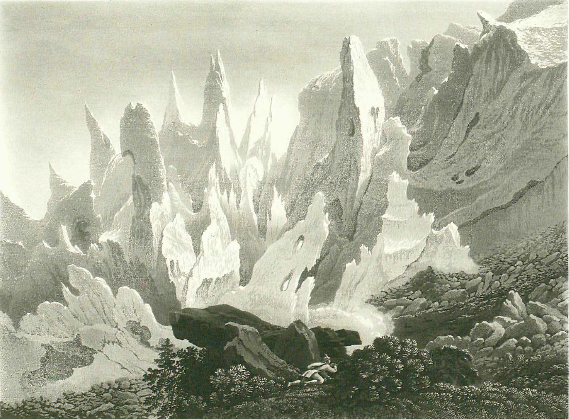
Translation: Horace-Bénédict de Saussure visits the Glacier des Bossons at Chamonix during the Little Ice Age

Like that of the Bois, the Bossons glacier is a spectacle of the Chamonix valley that most visitors will see. We pass below this glacier on the way to the Prieuré and there, at a small hamlet called the Bossons, which doubtless lent its name to the glacier, the guides await who offer to conduct travellers thither. 

Ice pyramids on the Glacier des Bossons
Engraving by Samuel Birmann of Basel (1793-1847)

It is a charming path, first through a small alder wood along the stream that comes out of the glacier, then through meadows and finally through a forest of fir trees. This last stretch is difficult because of its steepness, which is some thirty or thirty-one degrees. After overcoming this slope, the glacier is at hand, and one has the pleasure of seeing very close by the most beautiful pyramids of ice. As I have remarked before, wherever glaciers rest on a level plane, their surface is also more or less flat, but where they rest on a slope, their ice blocks topple and cram themselves together, taking on varied, often grotesque shapes and attitudes. Continuously washed by the waters that melt from them, the steep sides of these ice towers are absolutely clean and brilliant; neither sand nor gravel is to be seen on their flat surfaces, and they gleam a dazzling white where they reflect the sunlight, or a beautiful aquamarine green where the sun shines through them. Seen through the fir trees, which they often overtop, these brilliant and colourful pyramids make the most striking and extraordinary sight.

At the top of this short if steep ascent, one finds a stretch where the glacier rests on a level plane and offers a more or less equally flat surface. There, after crossing the dyke of stones and gravel that bounds borders almost any glacier, one can climb down onto the ice, cross the glacier and return to the Prieuré by a different route from the way up. As it is much narrower than that of the Montenvers, this glacier exhibits only a few of the great phenomena which we see on the Glacier des Bois. Nevertheless, there are quite large crevasses, and one can get an idea of the waves which we have compared with those of a rough sea. Travellers who have seen the Glacier des Bois can therefore dispense with the Bossons glacier but those for whom the Montenvers excursion is too strenuous would do well to go up to the Bossons, which is much lower.

Seen from the top of the Brévent, the Bossons glacier seems to descend directly down the side of the Mont Blanc valley. It is true that some optical illusions must be in play here, since the extreme brightness of the snow and ice, together with the absolute lack of aerial perspective because of the air’s purity, deprive the eye of any means of measuring distances, so that Mont Blanc, seen from Plianpra or from the top of the Brévent, appears to hover almost directly above the lower end of this glacier, even though there is really a horizontal distance of more than a league and a half. In spite of this distance, however, it is quite certain that snow and ice stretches uninterrupted from the summit of Mont Blanc to the bottom of the Bossons glacier. More than once, people have even attempted to reach the summit of Mont Blanc by entering this glacier at the top of the eminence known as La Côte, which separates it from the Taconay glacier.

Going up the eastern bank of this same Glacier des Bossons, one arrives at the Glacier des Pèlerins under the foot of the Aiguille du Midi, and then one can skirt the foot of the other aiguilles as far as Montenvers, making one’s descent along the Glacier des Bois. I did part of this route in 1761 but with too much haste; fearing benightment among these wildernesses, my guide made me descend with such haste that, as I was not yet fit enough to run through these mountains, I stumbled at almost every step. I did not return to Chamonix until well into the night, and this in a state of agitation and fatigue from which I had great difficulty in recovering.

References

Translated from Horace-Bénédict de SaussureVoyages dans les Alpes, édité et présenté par Julie Boch, Genève, Georg éditeur, 2002

Thursday, February 2, 2023

"Suddenly transported to a world forgotten by nature"

A visit to the Talèfre glacier on Mont Blanc during the Little Ice Age, as described by Horace-Bénédict de Saussure 

The view of the Talèfre glacier is majestic and awe-inspiring. As it descends an extremely steep slope, its jostling seracs surge up into towers and pyramids leaning this way and that, and threatening to obliterate any reckless traveller who dares approach them. To reach the glacier’s upper tier, where it is less steep and hence less broken up, we scaled the rocks to its left on the western side. Known as the Couvercle, this crag is dominated by an inaccessible summit, which as usual in these parts is called an “aiguille”, and taking the name of the nearby glacier, is known as the Aiguille du Talèfre.

View of the Talèfre glacier and the "Jardin" by Jean-Antoine Linck
Courtesy of the Alpine Museum of Chamonix-Mt Blanc

The slope by which one climbs the Couvercle is excessively steep; one follows a sort of groove that Nature has carved in the rock. Clinging to some nubbins of rock, we climbed with our hands as much as on our feet, or rather more so, which moved us to name this passage the “égralets” or ladders. However, the climb is not dangerous because the rock, a very coherent granite, always gives secure holds for one’s hands and feet, although its steepness would make it somewhat offputting on the descent. After reaching the top of these ladders, the slope angle eased and we walked over grass and large granite slabs to the edge of the Talèfre glacier basin. The basin is the high and more or less horizontal part where the glacier can be crossed.

It took us an hour and a quarter to climb from the Léchaud glacier to the Talèfre’s basin. We were tempted to rest for a moment before stepping onto it. Everything invited us to do so here, a beautiful lawn watered by a brook which emerged from under the snow and rolled its crystalline waters out onto silvery sands. Even more compelling, there was a view so vast and magnificent that no amount of description could do it justice. How could one, indeed, paint for the imagination these scenes that have nothing in common with anything seen in the rest of the world; how would one convey to the reader's soul the mingled impression of admiration and terror that is inspired by these immense masses of ice, which are surrounded and surmounted by these yet vaster pyramidal crags; the snow’s brilliance contrasting with the drab colour of the rocks streaming with the snow’s meltwater, the purity of the air, the radiance of the sunlight that lends an extraordinary sharpness and vividness to all these sights; the profound and majestic silence that presides over these vast solitudes, a silence disturbed only from afar by the crash of some great block of granite or ice falling from the top of some mountain, and the very starkness of these lofty crags, barren of any beast, or shrub or verdure of any kind.

Glacier du Jardin (detail) by Gabriel Loppe (1866)
MAH Museum of Art and History, Geneva

And when one calls to mind the beautiful herbage and the charming landscapes that one recently saw in the lower valleys, one could believe oneself suddenly transported to another world forgotten by nature. The view from Montenvers gives only a very imperfect idea of it; there you see only one glacier, whereas from here you see the three great glaciers of Les Bois, Léchaud and Tacul, not to mention a large number of less considerable ones which, like that of the Talèfre, pour their ice into the main glaciers.

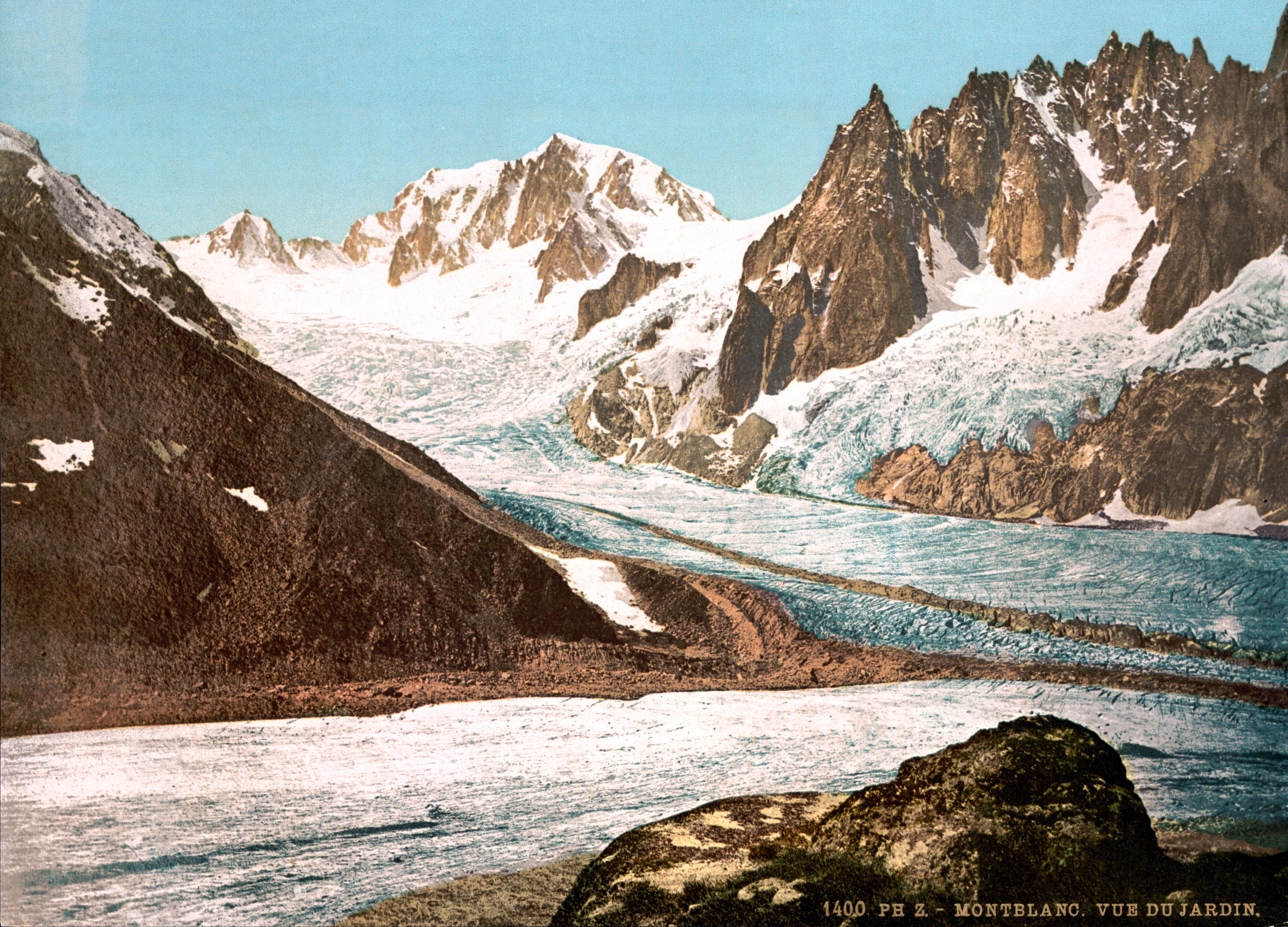
View of Mont Blanc from the "Jardin", c.1890
Wikipedia

After resting, and enjoying this beautiful spectacle, we walked onto the Talèfre glacier, and in twenty minutes came to a ridge of debris that divides the glacier along its length. As this was the highest point of our excursion, we took a long break to make observations with our instruments. To the south, the view from the middle of this glacier is similar to that from the Couvercle, but behind us to the north the Talèfre glacier itself, on which we stood, presents a scene as exquisite as it is singular. The glacier rises in stages to the foot of an exactly semicircular cirque, which walls it round it on the northern side. This cirque is formed by extremely high granite peaks, which end in sharply pointed summits of infinitely varied forms. The gaps between these peaks are filled by glaciers that flow into the Talèfre glacier. The same glaciers are crowned by snowslopes that rise in festoons sculpted in the shape of acanthus leaves between the black and vertical granite faces, where no snow can settle. The crest of this magnificent amphitheatre rises into the vault of the sky, which here takes on a blue so deep and azure that one could never see the like in the lowlands, and which singularly brings out the brilliance and contrast of the snow and the rocks.

A very singular piece of this picture is the flattened rock, situated like an island in the middle of the ice and snows of the Talèfre glacier. It is more or less circular in shape, standing a little above the glacier’s level. The eternal frosts that weigh on this whole region seem to respect it; they do not touch it, or at least they leave it much sooner than the rest of the mountain. This rock is even covered with a little greenery, which at this moment was only starting to appear, because early spring does not reach these high mountains until the middle of July, but at the end of August it would be covered with a beautiful lawn, spangled with a great variety of pretty Alpine flowers. The place is also known as the Courtil, a word that means 'garden' in both Savoyard and old French,. It is even walled in like a garden, since the glacier has deposited a ridge of stones and gravel around it, exactly in the manner of an enclosure. I very much wished to go there to see if there was not some hot spring, or some other local cause that melted the snow and favoured vegetation, but the deep crevasses of the glacier, lurking under soft and not very firm snow, would have made the way so dangerous then that our guides absolutely refused to take us there. Such a phenomenon is not unique in the history of glaciers; I have seen the like on Swiss glaciers, but perhaps not in such a beautiful situation, or covered with such beautiful verdure. When the snows have melted, this Jardin would be neither dangerous nor difficult of access.

After completing our observations, we set off again to finish our glacier crossing. We aimed to make our return on the opposite side, both to see new scenery and to avoid having to descend the “ladders”, which we reckoned would be even more awkward on the descent than they had been on the ascent. In crossing the glacier, however, we encountered more difficulties than had been apparent at first sight. If we moved on upwards, we would have to cross crevasses covered with snow, like those between us and the Courtil, and below us we saw frighteningly steep ice-slopes, while the middle way seemed to combine the hazards of both these extremes. While our guides were holding council, one of them, Pierre Balme, who is the one for whom I have the most regard and confidence since the death of Pierre Simon, and who was then in charge of the magnetometer, grew tired of the discussions and, deciding to underline his opinion by example, set off by the most direct route, and all but ran down the extremely steep slopes of sheer ice, edged as they were by declivities. We shuddered as we watched; the slightest false step would infallibly have cost him his life; but he came out of it scot-free. In such cases, there can be no middle way; either one must safeguard every move by cutting steps in the ice, or walk firmly enough for one’s bootnails to bite into the ice, and quickly too, so that there is no time to slip. Pierre Balme’s example decided us, and we followed, not exactly in his footsteps but down the fairly steep slopes, preferring these obvious yet transient dangers to the more drawn-out hazard of falling unexpectedly into a crevasse.

On leaving the glacier, we found ourselves on a slope of broken rock, by which we descended along a sort of corridor or gorge between the glacier on our right, and a large granite rock on our left, and this long and steep descent brought us back to the Léchaud glacier.

We were now facing the bottom of this glacier, which ends in a cirque bounded by the Aiguilles de Léchaud and by the Grande and Petite Jorasse. Like that of the Talèfre, this cirque is enclosed by granite walls crowned by extremely high peaks. Rising against these rocks, the ice gives way to very steep snow slopes that dwindle into narrow tongues between stark and vertical granite faces. Visiting this glacier in 1767, I went as far as the floor of the cirque and then climbed these snowfields as high as their ever-steepening pitch would allow; I then returned, skirting the foot of the Aiguilles de Léchaud and passing the boutes or caves of Léchaud, a sort of den made under the granite rocks to serve as an overnight refuge for crystal-hunters from Chamonix. There, for the first time, I had the pleasure of collecting Achillea nana, Gnaphalium alpinum and other alpine plants that grow there in small recesses with a good southern exposure.

On this occasion, we hurried back to Montenvers: clouds were piling up on the summits and the change of wind direction threatened bad weather, as already presaged in the morning by the sky’s deeper shade of blue. Walking as fast as we could on the ice, it took us nearly two hours from the bottom of the Talèfre glacier to the freshet near where we had stepped onto the glacier. On the way, we crossed several of those pretty streams, glinting like beryl or aquamarine in the sunlight, that flow along beds they have scoured into the ice. While quenching our thirst with this pure fresh water, we saw how several of the streams had joined together into a small river that cascades into a chasm of living ice, forming a beautiful waterfall.

Nearing the western edges of this great valley of ice by a somewhat different route from our outward way, we passed over great avalanche debris that had fallen in the spring from mountains above the glacier. Riven by large crevasses, just like the glacier, these snows had already congealed to a density close to that of ice, and, as they become saturated with water as the sun melts their surface, they will freeze during the following winter into ice exactly like that of the glacier itself. We returned to the château of Montenvers at five o'clock in the evening and, taking just a moment's rest there, descended thence in two hours to the Prieuré, somewhat fatigued but well satisfied with our day.

References

Translated from Horace-Bénédict de SaussureVoyages dans les Alpes, édité et présenté par Julie Boch, Genève, Georg éditeur, 2002

Monday, January 30, 2023

“Some courageous hunter might attempt this route”

Translation: a short walk on the Mer de Glace (Glacier des Bois) during the Little Ice Age, as described by Horace-Bénédict de Saussure 

As I said above, on July 15 we came up to stay at the Montenvers, so that we could leave at dawn the next day and venture down into the valley of ice. But where can you lay your head at the Montenvers? We slept in a château, for this is what the Chamoniards, a cheerful and mocking folk, ironically call the shabby refuge of the shepherd who guards the flocks on this alp. 

A view of the Montanvers by Carl Ludwig Hackert, c. 1781
Image by courtesy of Wikipedia

A large block of granite, carried there formerly by the glacier or by some more ancient turmoil, sits on one of its faces while another slopes up at an acute angle to the ground, thus leaving an empty space beneath it. The ingenious shepherd has sheltered himself from the circling winds by taking the projecting face of this block for the roof and ceiling of his castle, and the earth for his floor, and then walling this shelter round with dry stones. Leaving in the topmost part an open space, he has placed a doorway some forty inches high and sixteen wide. As for the windows, he has no need of them nor of a chimney; the daylight enters and the smoke seeps out through the gaps between the stones of the wall.

This is the interior of the Montenvers shepherd’s dwelling; this angular space between the granite block, and the earth and the wall forming his kitchen, bedroom, cellar and dairy, in sum all of what he calls his home. And he was kind enough to give it up to us for the night, which he himself spent with our guides in the open air around a fire that they kept going in the upper tracts of the forest. For ourselves, we strewed over the somewhat uneven floor of the castle a bale of straw that we’d brought up, yet we slept there better than one often sleeps in suites where art and luxury have exhausted all their resources. The next day, a little before daybreak, our guides came to awaken us: I was then fast asleep, and the light shining into us from behind them lit up the granite block under which we were lying so singularly that I was for some moments unable to understand where I was and what I saw.

The Glacier des Bois and source of the Arveyon
By Jean-Anthoine Linck (via Wikipedia)

We set out at daybreak, and began by skirting the glacier, following a path fairly high above it. At first, this path is safe and easy; but a quarter of a league from the Montenvers it loses itself on the steep slope created by the slanting planes of veined granite slabs. On the two previous occasions that I had passed there, I found footing only on a few rugosities or dimples in the rock, and if one of us had slipped, he would have fallen a goodly distance onto the glacier below. But in 1778, as soon as I arrived in Chamonix, I sent two men there, who, during our trip to Buet set off some blasting charges in the rock and made this passage, if not exactly easy, at least rather less dangerous. Those who follow in our footsteps to visit the glacier will be obliged to us for having facilitated their access.

There are two passages like this, one after the other, which are known as Les Ponts. Having got by them, we went down to the glacier’s edge and for a while followed its moraine, as the rock and gravel that borders a glacier are known. We went past a freshet that springs from the rock in a natural alcove; its water is of an admirable freshness and limpidity, and hosts some beautiful Ranunculus glacialis, which grow in large clumps in a rock cleft, carpeting the whole alcove. At this point, we thought we’d try walking on the glacier, but it was still too jumbled, because its bed is still too steep here. As mentioned above, when discussing glaciers in general, they are only practicable where they are more or less level and not disrupted by the slope angle or an uneven bed.

The glacier eventually became more tractable, and we returned to it an hour and a half after leaving the Montenvers. Here, however, we faced a new difficulty. It had rained the day before, and the drops had frozen as they fell onto the glacier, forming an extremely slippery ice on its surface, which is usually rough. So we put on crampons so that we could keep our footing and step up our pace. Here and there we found crevasses that were a little too wide to cross, or slopes that were too steep to cross above these abysses; but we nevertheless kept heading east-south-east across and up the glacier. On the way, we remarked how large accumulations of hail had filled up hollows in the ice.

After a good half hour of walking on the glacier, we crossed an ice ridge heaped with earth, sand and rock debris. The ice under these ridges rises much higher than in the gaps between them because the accumulated debris keeps the sun off the ice, preventing it from melting or evaporating. Ten minutes later we crossed a second ridge higher than the first, and we judged that the ice was twenty or twenty-five feet higher under this debris than where the air and the rays of the sun could act freely upon it. We came up to a third ridge twenty minutes from the second, and the fourth, the final one, was close by.

Here we found ourselves at the point where the Glacier des Bois forks into two streams, as mentioned above, of which the one veering to the right, towards Mont Blanc, is known as the Glacier du Tacul. The other, leftward, stream is the Glacier de Léchaud. It would undoubtedly be more interesting to follow the right-hand fork, thus heading for Mont Blanc. As they looked to us, its snow and ice fields seemed to be by no means unscaleable, but appearances are deceptive. Glaciers seamed with deep crevasses masked here and there by thin layers of snow defend the approaches to this formidable mountain, although perhaps in a year with heavy snowfall, and by choosing a season when the snow is still firm, some skilful and courageous hunter might attempt this route. But, as matters stood then, an attempt would have been completely impossible for us, and so we followed the valley’s left-hand After two hours walking on the Glacier des Bois, we left it at the bottom of the Talèfre, which is where the latter glacier pours its ice into the Glacier des Bois, which is known here as the Léchaud glacier. 

References

Translated from Horace-Bénédict de SaussureVoyages dans les Alpes, édité et présenté par Julie Boch, Genève, Georg éditeur, 2002

Thursday, January 26, 2023

“Worthy of any traveller’s attention”

Translation: how a glacier of Chamonix looked in the Little Ice Age, as described by Horace-Bénédict de Saussure

The Arveiron is a powerful torrent that issues from the lower end of the Glacier des Bois through a great arch of ice, which the local people call the Arveiron’s “embouchure” or mouth, although this is actually its source, or at least the first place where it comes out into the open air. One can get there, as I have said, directly by descending from Montenvers; but this is a path so steep and strenuous that I can hardly recommend it. From the Prieuré, by contrast, there is a charming walk of an hour or one could even take a carriage, all on the flat, across beautiful meadows and through a splendid forest.

Source of the Arveiron: print made by Sigismond Himely, 1820s
From the British Museum collection

The Arveiron’s source is worthy of any traveller’s attention. It is a deep cavern, with the entrance formed by a vault of ice more than a hundred feet high, and of proportionate width. Carved as if by the hand of nature, the cavern opens amid an enormous mass of ice, which shines opaquely and white as snow here, or a translucent aquamarine there, just as the light may play on it. From the bottom of this cavern, a river surges out, foaming white and, ever and again, tumbling in its waves large floes of ice.

Raising your eyes above this vault, you see an immense glacier, crowned by pyramids of ice, amid which the obelisk of the Dru thrusts upwards, its summit lost in the clouds. Finally, this whole picture is framed by the beautiful woods of the Montenvers and the Aiguille du Bochard, these forests running upwards alongside the glacier as far as its highest reaches, which merge into the sky.

The place where one enjoys this spectacle is extremely wild; since the ice has greatly diminished, there remain only piles of sand and blocks deposited by the glacier; one sees no verdure. But seven or eight years ago, when the glacier came down much lower, the ice cavern was situated next to a larch wood floored with a beautiful white sand sprinkled with clumps of the beautiful red blooms of the epilobium, the starry flowers of Sempervivum arachnoideum, and those of the Saxifraga autumnalis.

Source of the Arveyron: watercolour by Samuel Grundman, 1826
By courtesy of Chamonix City Office

I have sometimes been inquisitive enough to enter this cave, and indeed one can go quite far inside when it is wide enough and the Arveiron does not fill it up; but this is always a temerity, as the vault often drops large fragments. When we went to visit it in 1778, we noticed in the arch which formed the entrance to the vault a large, almost horizontal fissure, cut at its ends by vertical cracks. It was easy enough to see how this whole piece would soon come adrift and, indeed, a report like a thunderclap was heard that very night. This piece, forming the vault’s keystone, had collapsed, dragging down the whole outer part of the arch. The ice mass had then blocked the course of the Arveiron for some moments. Pooling up in the bottom of the cavern, the waters then burst abruptly through the dam, violently sweeping away all these great blocks of ice, smashing them to pieces against the rocks that stud the torrent’s bed and carrying the fragments far and wide. The next day, with a sort of horror, we saw how large slabs of this ice covered the place where we had stood the day before.

Interior of the ice cave at the source of the Arveiron
By Samuel Grundmann and J-P Lamy
Alpine Museum of Chamonix-Mont Blanc

So this is how the vault collapses and how it renews itself. In winter, it hardly exists; the shrunken Arveiron creeps out from under the ice, which slopes down to ground level, and it is only when the growing warmth of spring swells the waters of this torrent and melts away some of the ice that the rivers starts gnawing at the icy walls that resist its passage, and then those in the middle, no longer supported, collapse into the stream, which carries them along, successively breaking away more and more fragments until the upper part of the ice takes the form of a vault whose blocks hold each other up. This vault changes from day to day; sometimes it collapses entirely, but soon a new one is formed.

It may be asked why this glacier is the only one that ends in such a large and beautiful ice arch. This is because it is the only one, at least to my knowledge, which has ice of such great depth and consistency at its lower end, and which terminates on horizontal ground, and from which emerges such a considerable torrent, as all these conditions must be fulfilled in order to produce a beautiful arch. If the glacier ends on a steep slope, as they very often do, the slightest movement of the glacier causes the ice blocks to tumble down, giving an arch no time to form. Then, if only a little water issues from the glacier, the arch is necessarily narrow and low in proportion, because it is the breadth of the torrent which determines that of the arch, and thus its height. And if, finally, the ice is thin or fragile, no arch can be either sizeable or stable.

Moreover, this vault of ice is not always so impressive or vast, nor does it remain always in the same place. This is because the glacier sometimes advances into the valley, and at other times retreats. The granite blocks it has deposited show that it once descended much lower on this slope than it does today.

References

Translated from Horace-Bénédict de Saussure, Voyages dans les Alpes, édité et présenté par Julie Boch, Genève, Georg éditeur, 2002

Wednesday, November 17, 2021

No recovery for Switzerland's glaciers

The annual audit of snowfall, glacier wastage and permafrost depth in the Swiss Alps, as reported by the Cryospheric Commission of the Swiss Academy of Sciences

At low altitudes, the winter of 2019/20 saw the lowest level of snowfall ever. The loss of ice volume in Swiss glaciers continued in the summer of 2020, during which temperatures reached record highs. The influence of climate change on the cryosphere is very evident.

Meltwater channel on the Kanderfirn, 2018
Image by courtesy of Alpine Light & Structure

Weather and snow: little snow at low altitudes

In the winter of 2019/20, the mountains were covered with snow about two weeks earlier than normal, at the beginning of November. Record snowfalls for November occurred in some locations on the southern slopes of the Alps. 

Temperatures then reached record highs from December to February, more than 3°C over the long-term average.The following spring was also clearly too warm and characterised by a lot of sunshine. Below 1,000 metres, precipitation fell mostly as rain during the entire winter half-year. In terms of mean snow depth, this led to the winter with the least snow since measurements began, just ahead of 1989/90 and clearly ahead of 2006/07. 

At several stations, for example in Marsens/FR (718m), Einsiedeln/SZ (910m) or Elm/GL (965m), there had never before been so few snow days (days with at least 1 cm of snow). At some low-lying stations on the northern side of the Alps (eg Stans, Basel and Lucerne), no snow at all was recorded for the first time ever.

Above about 1,700 metres, however, snow depths were average in the northern Ticino and in the southern Valais, which was mainly due to the large snowfalls at the beginning of winter and in February.

Very warm between July and September 2020

With the exception of the measuring stations in southern Valais, the snow melted everywhere one to four weeks earlier than normal. The months of July to September 2020 were once again characterised by above-average temperatures. In contrast to the two previous hot summers, snow fell twice in August to just below 2000 metres. On the last weekend of September, the snowfall line on the north side of the Alps fell to as low as about 1,000 metres. Above that, 20 to 80 centimetres of fresh snow were recorded, which is unusual for this time of year, leaving the Alps in a thick white mantle.


Ice collapse on the Morteratsch Glacier, November 2011
Image by courtesy of Alpine Light & Structure

Glaciers: another 2% of ice volume lost

Between the autumns of 2019 and 2020, glacier loss continued relentlessly, but was somewhat less dramatic compared to the previous three measurement periods of 2016/17, 2017/18, and 2018/19. After average snow amounts were measured at the glaciers' elevations in early May, the summer melt was once again substantial. 

Over the entire year, low-lying shallow glaciers (eg the Glacier de Tsanfleuron/VS) showed an average reduction in ice thickness of two metres. Glaciers in southern Valais as well as in Ticino and the Engadin (eg the Findelgletscher and the Ghiacciaio del Basodino) lost only about half a metre in thickness, which can be attributed to the large amounts of snow in early winter as well as the positive effect of the summer snowfalls. 

The amount of snow on the Silvretta glacier in Graubünden was about the same as the average for the past decade. This shows that 2019/20 was not an extreme year in terms of the current situation - despite massive losses of about 2% of the remaining glacier volume in Switzerland. 

All glacier tongues are receding

The shrinkback of glacier tongues reflects weather conditions over a period of several years rather than the effects of a single year. Climatic conditions affect the position of the tongue with a varying lag depending on the tongue’s location. The fact that the autumn measurements showed a further reduction in the length of glaciers is therefore hardly surprising. 

With two exceptions, the glaciers showed a shrinkage of up to 25 metres. Massive recessions of more than 50 metres were seen at Kanderfirn/BE and Sankt Annafirn/UR. In both cases, the tongues have thinned out increasingly in recent years and have now literally disintegrated.


Block glacier in Val Sassa, 2021
Image by courtesy of Alpine Light & Structure

Permafrost: 11 metres of thaw layer on the Schilthorn 

On the 20th anniversary of the Swiss Permafrost Measurement Network Permos, all permafrost measurement parameters have reached or exceeded the record values posted in 2015.

Due to the early snowfall in autumn 2019, the permafrost accumulated a lot of heat. As a result, surface temperatures were above average, especially during the winter, while annual averages were in the range of the extremely warm years of 2003, 2015 and 2018. The high surface temperatures led to an increase in the depth of the thaw layer – the uppermost metres above the permafrost that thaw each summer. 

The previous record values were reached or exceeded everywhere, from 2.8 metres at Flüela/GR to 11 metres on the Schilthorn/BE. The latter is the deepest thaw layer ever measured in Swiss permafrost. Since the beginning of measurements in 1998, the depth at this location has more than doubled. Across Switzerland, the increase on the previous year ranges from a few centimetres to half a metre.

End of the short recovery

The short break in the warming trend that was seen after the snow-sparse winter of 2017 is definitely over. Permafrost temperatures are again similar to or even higher than in the previous record year of 2015. But the permafrost reacts to the changes at the surface only with a long lag time, implying that the warm conditions of recent years have not yet fully penetrated into the depths. 

The creep rates of rock glaciers generally follow the trend of permafrost temperatures. Compared with the previous year, they have again increased by an average of 20% on the previous year, exceeding the previous record values from 2015 in some cases.

Text: Matthias Huss, Christoph Marty, Andreas Bauder und Jeannette Nötzli


Retreat of the Forno Glacier
Image by courtesy of Alpine Light & Structure

Appendix: New radar system used to measure glacier ice depth 


Data on the extent of glaciers and their ice thickness are of interest not just to alpinists but also to forecasters of future glacier retreat and runoff, as well as for the assessment of glacier-related natural hazards. In close cooperation with Swisstopo, the Swiss Federal Office of Topography, the Swiss Glacier Monitoring Network Glamos has therefore compiled a new detailed inventory of the country’s glaciated areas. In 2016, glacier ice covered 961 square kilometres or 2.3% of the country's surface.

In addition to the inventory, a project at ETH Zurich, a new type of helicopter-borne radar was used to measure the ice depth of all larger glaciers. Ice depth measurements are now available along a total track of more than 2,000 kilometers, which makes it possible to determine the total ice volume.

The volume of all Swiss glaciers for the reference year 2016 is estimated at 58.7±2.5 cubic kilometres. Distributed over the area of the whole of Switzerland, this corresponds to a water layer 1.3 metres deep. In line with the extent of the glaciers, ice volume is concentrated mainly in the Bernese and Valais Alps, but considerable volumes are also found in central and eastern Switzerland. 

The Great Aletsch glacier – the largest Alpine glacier at just under 80 square kilometres – accounts for 11.7 cubic kilometres of ice. Thus, it alone stores about 20% of Switzerland's glacier ice. By combining these results with annual measurement data, it is possible to determine what proportion of the existing ice has been lost. The numbers are impressive: since 2000, Swiss glaciers have lost just under a third of their remaining ice mass, and in an extreme year the loss can amount to more than 3% in a single year. 

The extent of glaciers and their depths can now be can now be viewed directly on the official online map of Switzerland at map.geo.admin.ch. The map shows the most important most important parameters such as area, volume or the maximum and the average ice thickness for the respective glacier.

Source


© Die Alpen, journal of the Swiss Alpine Club, 06 2021 edition. Originally published in German. This is an unofficial translation by MAGE/Captain. Images and charts of original article are not reproduced here. 


Monday, March 9, 2020

Climate pioneer

How Alfred de Quervain took the measure of Greenland's icecap

Just like Greenland, we thought when we first set eyes on the Claridenfirn – so vast and open were the views across this icy altiplano in the Glarus Alps of Switzerland.


Back in Zurich, a quick Google suggested that the comparison wasn’t so wide of the mark. For a link does exist between our local icefield and the world’s largest, most heavily glaciated island. It turns out that the Claridenfirn was first researched by a Swiss explorer who, just over a century ago, also led the first west-to-east Greenland crossing. Now a special exhibition at the Swiss National Museum in Zurich commemorates this feat.

Alfred de Quervain
Alfred de Quervain (1879-1927) may be the most famous arctic explorer that few outside Switzerland have ever heard of. Ironically, in these warming times, it was fears of a renewed freeze-up that helped to launch his career. When the young de Quervain finished his meteorological studies in Bern and Paris around the turn of the last century, Europe had just emerged from the “Little Ice Age” and the Swiss authorities were keen to understand what drove such climatic variations.

View of Grindelwald at the end of the "Little Ice Age"
The ice continued to occupy de Quervain’s thoughts after 1906, when he took up an appointment as Adjunct-Director of Switzerland’s nascent meteorological agency. Inspired by Fridtjof Nansen’s pioneering crossing of Greenland in 1888, de Quervain wondered what conditions would be like further north, closer to the icecap’s midriff.

A reconnaissance was made in 1909, reaching a point some 85 kilometres from the coast. This was a salutary test: the party met with all the usual dangers and annoyances that face Greenland travellers, including crevasses, meltwater lakes, and winds that threatened to blow their tents away.

Crevasses in Greenland
In April 1912, the Swiss expeditioners came back to make a full crossing – west to east, in the opposite direction to Nansen, so that they could avoid overwintering. Keeping the costs down was key: as for Captain Scott around the same time, support from the public purse was limited.


Instead, funding came from scientific institutions, private donations and a newspaper sponsorship by the Neue Zürcher Zeitung. The government did step in later to guarantee the expedition’s debts. And, as companies made contributions in kind, the party consumed a lot of Maggi soup.


The expeditioners came from varied backgrounds: Roderich Fick was an architect, Karl Gaule an engineer and Hans Hössli, a doctor as well as a member of the Academic Alpine Club of Zurich. To weld this team together, de Quervain took them on a shakedown climb in the wintry Engadine. But learning how to drive dogs had to wait until they arrived in Greenland.


In the preface to his expedition book, de Quervain says “On the one hand, we took great risks. But on the other, we were so exact in devising and working out our preparations that perhaps some interesting but avoidable situations did not occur. Such would have been sensational and not to the credit of a serious undertaking.”

The words may be disingenuous. Like any expedition, they had their share of interesting situations. In the first few days, the sketchiness of their driving skills led to near-disaster, when two of their three sledges broke through thin ice into a glacier lake, complete with dogs and drivers.


Fortunately, all was retrieved. The sleeping bags stayed dry in their waterproof packing and – much to the credit of this serious undertaking – de Quervain had arranged for the all-important supply of matches to be welded into tins and dispersed between all three sledges. His Ulysses Nardin chronograph – vital for navigation – did get waterlogged, but he managed to fix it.


In the end, their resourcefulness saw them through. Despite several more mishaps – the dogs kept eating their traces – they covered 640 km in 31 days, reaching Ammassalik on the east coast in late July. On the way, they reached an altitude of 2,510 metres, gathering a trove of geographical and weather data. Two colleagues who’d stayed on the coast made more detailed meteorological observations, once tracking a weather balloon up to 39,000 metres.

Another expedition result may resonate with an even stronger vibe today:-

Among the insights […] we gained is the realization that we […] in fact have become slaves of our slogans “faster, faster” and “more and more”. Do we believe that the quality of our lives is improved tenfold by going ten times as fast, or hearing and doing ten times as much every day? What if the value of our impressions turns out to be correspondingly superficial as they grow more fleeting? What do we win? […] But we stand here at a threshold. From here on the law of our souls will always say: If the sensations reach us ten times faster, their impression will diminish tenfold, with the result that we will be the poorer the hastier we live. That is a small truth I have learned from the icecap, from the midnight sun and the hundreds of little wrinkles in old Kitsigajak’s face. It is another of the expedition’s results that I must not suppress.


Old Kitsigajak

Back in Switzerland, de Quervain wrote an expedition book that has been reprinted several times – although not yet, alas, in an English translation. Remarkably, he was able to illustrate this account with colour photographs.* Together with a series of public lectures, these efforts helped to pay off the expedition’s debts.


Meanwhile, the expeditioners worked up their scientific results. These have gained in importance over the years. De Quervain’s profile of the icecap now serves as a baseline for researchers (several of them Swiss) who are trying to establish how fast Greenland is melting.


De Quervain never forgot the ice. Having developed a keen interest in glaciology, he took part in official studies of several glaciers in eastern Switzerland. His survey of the Claridenfirn started in 1914, making this glacier the longest continuously studied ice-stream in the world.

But how far into the future will it continue to be studied? A few summers ago, the Sensei and I took our niece to see the Claridenfirn. We wanted her to see the glacier in something like the state that de Quervain found it. In recent years, the lake at the glacier’s tongue has been growing fast.


References

 “Greenland 1912”, Exhibition at the Swiss National Museum, Zurich, 6 February – 19 April 2020.

William Barr, "Alfred de Quervain’s Swiss Greenland expeditions, 1909 and 1912," Polar Record, 51 (259). Map is reproduced from this article.

Alfred de Quervain, Quer durchs Grönlandeis: Die Expeditionen 1909 und 1912/13, Verlag Neue Zürcher Zeitung, edition 1 January 1998.

*Note

The previous year, at the other end of the planet, Herbert Ponting had failed to impress with similar efforts. Captain Scott’s diary for 25 April 1911 notes that “Ponting has taken some coloured pictures, but the result is not very satisfactory and the plates are much spotted.” See Liz Watkins, “Mapping the Antarctic: Photography, colour and the scientific expedition in public exhibition”, Chapter 24, in Progress in Colour Studies: Cognition, language and beyond, edited by Lindsay MacDonald, Carole Biggam and Galina Paramei, John Benjamins BV, 2018.