Friday, June 24, 2022

Musings on mountain names (3)

Naming mountains after people can lead to unforeseen complications

Johann Wilhelm Fortunat Coaz (1822-1918) has an alpine hut named after him, but no mountain peak. That is probably how he would have liked it. In the Swiss Alpine Club’s yearbook for 1865, the eminent Swiss surveyor, forester and alpine pioneer set out his position as follows:

By and large, naming summits after people is not something that I can favour. I feel that it is presumptuous of our generation to associate our fleeting lives with mountains that are hundreds of thousands of years older than we are, and that will outlive us by an equal span.

At the Hotel des Neuchatelois: where mountains were named after people
Illustration by Paul Hertig, Biel

Two years previously, Switzerland’s ruling council had summarily rebranded the country’s highest summit, in honour of an even better known surveyor than Coaz. Thus it was that Monte Rosa’s Höchste Spitze transitioned into today’s Dufourspitze (4,634 metres).

Whether or not it was this episode that got Coaz’s goat is unknown to this blogger. But, in general, it seems that most of his countrymen have always agreed with him: mountains should not be named after people.

Yet, even in the Swiss Alps, a few exceptions crop out. As noted in the previous post, the Austrian surveyor Ludwig von Welden (1780-1853) did name a few subsidiary peaks of the Monte Rosa massif after their early pioneers (including himself). This was in the 1820s. But he bestowed these names from the Italian side of the massif, even if they were afterwards acknowledged on Swiss maps too.

Some years later, though, a sprinkling of entirely Swiss family names appeared on those maps. And, unlike the Monte Rosa subpeaks named by von Welden, which straddle the Swiss-Italian border, the mountains so affected lie entirely within Switzerland.

It is here, in the remote Grimsel region, that we find an Escherhorn, an Agassizhorn, a Desorstock and a Studerhorn, among others. These names can be traced back to a sunny evening in 1840 at the “Hôtel des Neuchâtelois”. This was a large boulder that served as a summer bivouac for a group of largely French-speaking natural philosophers while they pursued their investigations into the icy world around them. The work was led by Louis Agassiz (1807-1873), soon to win fame as the leading proponent of a former Ice Age.

Louis Agassiz, Ice Age pioneer

After a hard day’s work probing into the secrets of the Unteraar Glacier, the assembled savants asked their guide what the surrounding peaks might be called. Jakob Leuthold, a local man from the Haslital, replied that, except for the Finsteraarhorn and the Oberaarhorn, none had names. Whereupon the savants decided to fill in these blanks on the map. So, starting with the Scheuchzerhorn, to honour an eighteenth-century pioneer of alpine research, they proceeded to memorialise some more recent scholar-mountaineers, including themselves.

“Memorialised” may be to overstate the matter. For sure, these names still appear on Switzerland’s official maps. But, after less than two centuries, their associations with historical figures are already fraying at the edges. Take the Studerhorn. Already people have difficulty remembering – and agreeing – which of two candidates it might commemorate. Was it Gottlieb Samuel Studer (1804-1890, right), a founder of the Swiss Alpine Club, or, perhaps a shade more likely, his cousin, the eminent geognost Bernhard Rudolf Studer (1794-1887)?

By contrast, nobody can forget whose name adorns the Agassizhorn. And that is the problem. For after catapulting himself to worldwide fame for his glacial researches, the great scholar crossed the Atlantic to become a professor of geology and zoology at Harvard University. And there, much later in his career, he published views about the origins of the human race that have since become incendiary.

As a result, some propose that the Agassizhorn should be “cancelled”. In 2008, Sasha Huber, an artist of Swiss-Haitian heritage, flew in a chartered helicopter to its summit. There she planted a placard calling for the peak to be renamed the “Rentyhorn”, after an ex-Congolese slave whom Agassiz had caused to be photographed in support of his theories.

To date, the Agassizhorn can still be found on the official maps. But even if it were to be rebranded, that would still leave a plethora of geographical features named after the glacial pioneer, including several more mountains, all in North America, to say nothing of a glacier and a creek, as well as a Crater Agassiz on Mars and a main-belt asteroid.

It will probably be a while until the world sorts through all the historical complexities that can arise from naming mountains after actual people. Until then, Coaz’s sound advice, as quoted above, might deserve some wider consideration.

References

Paul Hertig, Wie die Berge zu ihren Namen kamen: Wer waren die Männer die mit Gipfelnamen geehrt wurden?, Einwohnergemeinde Guttanen.

Monday, June 20, 2022

Musings on mountain names (2)

Map-making didn't always bring order to the medley of mountain nomenclature

The Gran Paradiso stands out as Italy’s sole 4,000-metre peak. In the summer of 1860, though, it proved difficult enough to find, let alone scale. As explained by John Jermyn Cowell (1838-1867), a Cambridge “Apostle” turned alpine pioneer, the problem was this:

Some mountains, which undoubtedly have a material existence, are unfortunate enough to have no name (for which reason, of course, I cannot point out an example); and on the other hand, some mountains which undoubtedly have names – and well-known names too – such as the Aiguille de la Vanoise and Mont Iseran, unfortunately have no material existence. But the Grand Paradis, previously to 1859, suffered from both these disadvantages at once …


Proof positive that the Gran Paradiso exists
Image by courtesy of Alpine Light & Structure

The European Alps had no monopoly on nameless peaks. When Japanese climbers inaugurated their own “golden age” of mountain exploration, in the early twentieth century, they came up against the same sort of lacunae. This was particularly the case in remote regions such as "the innermost mountains of Sunshū Tashiro”, soon to be rebranded as the Southern Japan Alps. In an early edition of the Japanese Alpine Club’s journal, Ogino Otomatsu describes a trip to this fastness in September 1906, less than a year after the club’s establishment:

From time to time, we could see through the trees, on the other side of the valley, a mighty peak, bare-topped and reddish, in the midst of the Akaishi range. When I asked Kōhei, our hunter-guide, what it was, he called it Warusawa on account of the extremely dangerous gully that drains the waters of this mountain into the Nishimata. This sounded much as if he had just said the first thing that came into his mind …. (as quoted in Nihon Hyakumeizan).

Neither Cowell nor Ogino could refer to modern maps of their respective mountain ranges. As one would expect, it was the surveyors sent out by central governments who did most to fix mountain names in place. In a paper entitled “Mountains have names!”, Professor Martin Scharfe, a cultural historian from Bavaria, tells the story of Ludwig von Welden, an officer in the Austrian imperial service who had somehow ended up in Italy.

In 1821, von Welden visited the Monte Rosa group, which straddles the Swiss-Italian border with the aim of surveying it. But he soon found that none of its individual summits were named. Any and all high peaks in the region were pointed out to him as “Monte Rosa”. But, making a virtue out of necessity, he proceeded to make good the deficit, naming many of the previously anonymous peaks for pioneers of the range. This is why we now have the Zumsteinspitze, the Parrotspitze and the Vincentpyramide. And von Welden himself was immortalised in the Ludwigshöhe (4,341m).


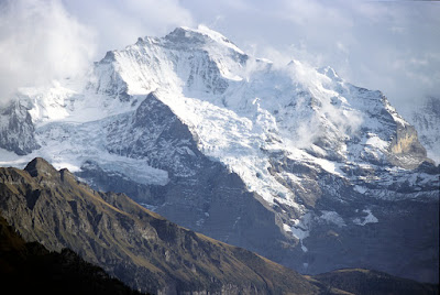
Today's monomial Jungfrau
Image by courtesy of Alpine Light & Structure

Elsewhere in the Alps, so far from lacking a name, some prominent peaks had an excess of them. As late as the decade and a half between 1775 and 1790, so Martin Scharfe records, four names each were in use for the Bernese Oberland’s Eiger and Jungfrau, and a “whopping seven” for the Mönch, the mountain that sits between them. Small wonder that Conrad Escher von der Linth, a Zurich-based silk merchant and mountain maven, complained in 1806 that the “muddling and confusion of names … was getting out of hand”.

As in the Alps, so in Japan. In his Nihon Hyakumeizan, Fukada Kyūya records many a case where the inhabitants of different valleys called the same mountain by different names. Or the same name drifted from one mountain to another over time.


A White Crumbling Peak also known as Kaikoma
Image by courtesy of Alpsdake (via Wikipedia)

Take Kaikoma, for example. This great pyramid of shattered granite obtrudes itself from the northern apex of the Southern Alps. That is why Shinshū folk used to call it Shirokuzure-yama, the White Crumbling Peak. But the name in use today makes it one of Japan’s many “horse mountains”, akin to one of those plentiful Rossbergs or Rossstocks in the German-speaking Alps. Indeed, there is another horse mountain just down the road, in neighbouring Kiso province. But neither name was sufficiently poetic for Monk Kairyō, who used yet another alternative in this deftly turned tanka:

Hills lap over valleys in the mountains of Kai
Alone amid the clouds floats Tetsuri-no-mine
The azure beauty of its summit stands forth
When the snows melt in May, against the blue sky .

In the Alps as in Japan, it fell to the modern mapmakers to impose order on mountain nomenclature.In Switzerland, the first nationwide mapping surveys were organised by General Henri Dufour (1787-1875), whose name has, by official decree, adorned the highest summit in the Monte Rosa massif since 1863. In the course of this rationalisation, some perfectly serviceable names were lost for ever.


Formerly known as the Silver Beard, or perhaps Saddle
Image by courtesy of Alpine Light & Structure

For example, the sweeping frontier ridge once known as the Silberbart (Silver Beard) was restyled (by Dufour) as the Lyskamm – although, according to Martin Scharfe – nobody has a clue where this name came from. But another authority says that the Lys element refers to a valley on the mountain’s southern, Italian, side. And also that the mountain’s previous name was not Silberbart but Silberbast (Silver Saddle).

As this episode suggests, chaos no less than clarity could proceed from the surveyors’ efforts. Professor Scharfe goes so far as to say that “A substantial number of the mountain names that are familiar today probably resulted from simple misunderstandings – misheard or mistranscribed, mistakes that went unnoticed at the time.”

This might be particularly true if the surveyor in question was deaf. The unfortunate Peter Anich (1723-1766) from Perfuß near Innsbruck had lost his hearing early on, Professor Scharfe records, so that “one had to shout every word slowly and clearly, directly into his ears, if one wanted him to understand”. Unsurprisingly, this “caused him more than a little trouble (as can easily be deduced) in his geometric work, especially because of the many names of the places he measured and the rivers and districts he described.”

Much the same could happen in early modern Japan. A mountain of the Jōshin-Etsu region called “Warimeki-yama” (Crevice Peak) is reliably attested in the nineteenth century yet appears nowhere on modern maps. Musing on this mystery, the Hyakumeizan author Fukada Kyūya posits that the army surveyors simply misheard the name as they passed through: “Warimiki did you say? Aha, that’ll be Waribiki then.”

In a way, these cases are curiously reassuring. It’s as if the untamed mountains, the realm of nature, have successfully resisted all human attempts to impose order on them.

References

J J Cowell FRGS, “Two ascents of the Grand Paradis”, in Peaks, Passes and Glaciers, Second Series, Vol II, London 1862.

Martin Scharfe, ‘Mountains have names’: on the history of how mountain names became established, Bavarian Studies in History and Culture, English version, 2021.

Nathalie Henseler, Gipfelgeschichten: Wie die Schweizer Berge zu ihren Namen kamen, Faro im Fona Verlag AG, 2010.

Fukada Kyūya, One Hundred Mountains of Japan, Hawaii University Press, 2014. 

Wednesday, June 15, 2022

Musings on mountain names (1)

Investigating the curious case of the Thirty-Three Bay Mountain

Sanjūsangen-zan is an 844 metres-high eminence that sits on the prefectural border between Fukui and Shiga Prefectures. What an evocative name that is. It links the mountain with one of Kyoto’s most storied temples – the Sanjūsangen-dō, founded in 1164 by none other than Taira no Kiyomori (1118-1181), the overlord who first brought martial rule to Japan. And then, for his sins, died a fiery death from an unquenchable fever.

The fever of Taira no Kiyomori
Woodprint from the Fitzwilliam Museum collection

But does the Mountain of the Thirty-Three Bays – a literal rendition of Sanjūsangen-zan (三十三間山) –  really have anything to do with this temple? Sometimes there may be less to a mountain name than meets the eye, as Fukada Kyūya here and there points out in One Hundred Mountains of Japan. In the essay on Mizugaki-yama, for example, he casts doubt on whether this high-sounding name really had such exalted roots:

When our ancestors named mountains, they certainly did not trouble themselves to consider mountaineering organizations looking for titles for their magazines. Far from being inspiring, the names they chose were extremely down-to-earth. Taking their cue from a mountain's color or shape or state, they came up with names like Spear (Yari), Red Peak (Aka-dake), or Landslide (Ōkuzure). Or they borrowed from the implements in their daily round, as in Basket (Zaru), Saddle (Kura), or Screen (Byōbu).

So, the Hyakumeizan author suggests, Mizugaki’s name probably had little to do with the “inner sanctuary” that its written form suggests. Instead, it may have started out as a corruption of “mitsunagi”, a word indicating where three ridges run together. 

Mizugaki-yama: probably not an inner sanctuary
Image by courtesy of Σ64 (via Wikipedia)

Hijiri-dake, a three-thousander in Japan’s Southern Alps gets the same sort of take-down. “Who could fail to be intrigued by Hijiri, the Peak of the Saint?” asks Fukada at the start of his essay, adding that “it is a name that befits this splendid mountain.” Alas, he is merely setting us up for disappointment:

Being for the most part pragmatic, rough-and-ready folk, we Japanese name most of our mountains for everyday objects that are brought to mind by the actual and obvious shape of the terrain. Elegant, literary appellations are correspondingly rare. This Hijiri-dake is no exception. A gully runs up into the mountain from the upper reaches of the Ōi river. As it is necessary to sidle along ledges ("hezuru") to get through this dangerous gorge, the place was called "hezuri-sawa". Corrupted into "hijiri", this name was afterwards taken by the entire mountain. This, at least, was the explanation that I remember reading in a book by Kanmuri Matsujirō …

This is not to say that all of Fukada’s mountains take their names from workaday tools or obvious geographical features. Some names enshrine their peak’s religious significance, as in Daibōsatsu, Nantai, Ryōgami, Yakushi-dake and Zao. Others may echo a folk legend, like those of Shiomi-dake and perhaps Naeba-san. And some are simply obscure: nobody can really explain how Tsukuba and Gassan got their names, although oddly both seem to incorporate the moon.

View of Sanjusangen-zan
Photo courtesy of Yama-to-Keikoku

So where does that leave us with Sanjūsangen-zan? Is it a corruption of some local dialect word, or is it really linked to that Kyoto temple? If you prefer the latter story, a glance at YamaKei’s gazetteer of Japanese mountains gives grounds for hope:

The unusual name of the mountain is said to derive from the fact that the building timbers of the Sanjusangendō in Kyoto were felled here. It is likely that the lumber felled on the mountain was first transported by the Amasukawa River and then drawn over the low Mizusaka Pass to Lake Biwa. Even today, old beech and mizunara oak forests remain on the Fukui Prefecture side of Sanjusangen-zan, reminding us of long ago when the trees were felled.

You know, if YamaKei’s write-up isn’t historically attested, then it deserves to be. You could imagine that, one day, a young savant might take isotope samples from the wooden columns in the Sanjūsangen-dō and trace them right back to their terroir on the slopes of the Thirty-Three Bay Mountain. Or, on second thoughts, perhaps the savants should keep their hands off this one. Some legends are best left uninvestigated.