Showing posts with label guidebooks. Show all posts

Tuesday, September 9, 2025

Mountaineering in Greater Japan (5): "offers fine sport"

Concluded: Walter Weston's guide to alpine activities across the Empire during the 1930s.

Like its adopted parent, Japan, Korea – now known as Chosen – is a land of mountains. Few of its ranges present, from the technical point of view, serious climbing problems to the mountaineer, and from the point of view of altitude they are not imposing. The highest is the peak known to the Koreans as Faik-tu-san, and to the Japanese as Haku-to-san, i.e. "The White-topped Mountain." and its altitude is some 9,000 feet. The ascent of it was made by Sir Francis Younghusband in 1886 without difficulty. It stands on the Manchurian border of Korea, but presents little interest from the climbing point of view.

Insupong (Korea): a granite formation.
Original image and title from The Lonsdale Library Mountaineering.

In spite of the low altitudes, some fine rock-peaks, mostly granite, from 2,000 to 6,000 feet, are to be found in various parts of the country and these mostly afford quite difficult climbing. The best-known group is Kongo San, the "Diamond Mountains," rising about the middle of the north-east coast, comprising an area of about 10 miles square with granite summits ranging up to 5,500 feet. They are famed, among both Japanese and Koreans, for their scenic beauty. The best periods for climbing are spring and autumn and the group is readily accessible by rail and motor-car from Keijo (Seoul), the capital, in less than a day. Keijo itself is on the main railway line from Peking to Japan, and about thirty-six hours by rail and sea from the Japan ports, or about half that time by air. The peaks of Umi Kongo, those nearest the coast, afford the best scrambling. Shusenho (4,450 feet) has several summits, each providing an excellent day’s work.

Climbing of equal excellence can be obtained within a few miles of Seoul, though the heights here are lower. Insupong, a fine, almost egg-shaped peak (2,800 feet), and Bankeidai, the same height with three main summits, offer fine sport. Five miles farther north of Seoul lies Manjoho (2,000 feet), a gigantic tooth offering several routes, all difficult. This is reached by half an hour's motor drive followed by one and a half hour's walk; the ascent is a difficult face climb needing great care. Rather lower but of even greater interest is Goho, the Five Brothers, two of whose five rocky summits are crowned with cube-shaped monoliths probably not yet ascended.

These granite battlemented ridges and towers of Korea in many cases resemble the finest parts of the granite cliffs of Cornwall south of the Land’s End, though much higher. There are no guides available, though stout coolies can usually be obtained as companions to the feet of the rocks themselves. The chief, perhaps sole, European authority is Mr. C. H. Archer, of the British Consulate-General in Seoul, from whom, or from his successor, information and advice would be always willingly afforded. From the headquarters of the Japanese Alpine Club in Tokyo, introductions will generally be furnished to members living in Seoul.

Formosa

The island of Formosa, now known to the Japanese as Taiwan, lies about 500 miles south of Japan proper and some 100 miles east from the coast of China. It is 240 miles long and its greatest breadth is about 80 miles. While its western half and a narrow strip on the south-east are flat and fertile, nearly the whole of the remainder of the island is mountainous and covered with dense forests. It contains at least five of the highest peaks of the Japanese Empire. Of these the loftiest, formerly known to Europeans as Mount Morrison, is Niitaka (12,960 feet), “the new high mountain,” in contradistinction to Fuji-san, hitherto, as its name implies, the highest in Japan. Next comes Tsugitaka, or “next high” (12,897 feet). It was previously entitled Mount Sylvia. 

Most of the others are still unknown to the Western world, and some are virgin peaks. As a result of the activities of the Formosan Mountaineering Club, however, new routes are being continually opened up, and it is to the officials of that Club, whose present headquarters are to be found in the Imperial Government Building in Taihoku, the capital, in the extreme north of the island, that intending mountaineers should apply for information. They can be relied upon for every assistance.

It is the dense forests of Formosa that render these peaks difficult of access, while the deep and precipitous valleys by which on the east coast they are approached constitute a further obstacle. Police paths are being constructed, where needed, in every direction, and some of these are wonderful feats of engineering; they are notably in connection with the remarkable East Coast Road.

The “‘timber-line” is approximately 12,000 feet. There is very little snow usually to be found on them, though a certain amount lies on Tsugitaka in ordinary seasons. The best months for climbing are (1) November and (2) May. Owing to the heavy rainfall frequently experienced, some of the police paths, and police posts, and even portions of the great East Coast Road, are liable to damage. Modifications of the following routes may therefore occasionally have to be made, but the Formosa Mountaineering Club, already referred to, will usually be able to help with the latest information, while the police authorities themselves are always courteous and obliging to properly accredited visitors.

It is essential, however, that at least one member of any party of mountaineers should be able to speak English.

Niitaka (12,960 feet) was first ascended in 1896 by Dr. S. Honda and a party of Forestry officials. There are no “technical” climbing difficulties and only the final 2,000 feet require any effort. The two most usual routes are from the north-west, the first (a) lying mainly up a tributary of the Dokusui River, and the latter (b) by the well-known Ari-San light railway, which brings down the timber from the forests of that name.

(a) From the station of Nisui, on the west coast railway, about 100 miles south of Taihoku, a branch line eastwards takes one to the small town of Suiriko in two hours. Then a timber trolley-line mounts in some ten hours to the police post of Tompo, 22 miles distant, at the foot of Niitaka (7,000 feet) and 4,000 feet above sea-level. Hence the road ascends by easy gradients for 14 miles, up a fine valley, to the police post of Hatsūkan, on a shoulder of the mountain. From here it is 2 miles farther on to the police post of Niitaka, from which the summit rises westwards and is gained without difficulty.

The top consists of a rocky platform some 30 feet long on which stands a triangulation post, a small concrete shrine in honour of the Spirit of the Mountains, and a brass indication dial. Four rocky buttresses fall to N., S., E., and W. respectively, on some of which excellent rock-climbing can be found.

The descent by the Ari-San route leads via the police post of Niitaka and that of Taataka 7 miles lower down, together with a journey of some two hours on the Ari-San light railway to the station of Kagi on the west coast main line, about two hours north of Tainan, the southern capital of Formosa.

With the ascent of Niitaka can be combined those of Shūkōran (12,577 feet) and Maborasu (12,487 feet), starting from the police post of Shūkōran, at a height of 9,700 feet. The former will occupy about four hours to the top, and is tedious rather than difficult, but when Maborasu is also included, it may be necessary to bivouac on the saddle between the two peaks before the descent to the police post.

A more interesting region, and one less familiar to Western mountaineers, is that lying to the north-east of the Niitaka group. It has the additional advantage of affording in its approaches the opportunity of seeing something of the wonderful East Coast Cliffs, amongst the most remarkable of their kind in existence. The chief summit of this group is Mount Tsugitaka, “the second highest peak” in the Empire.

Leaving Taihoku early in the morning by the East Coast Railway one goes southward to Ratō and then changes into the light railway serving the extensive forestry works on Mount Taiheizan. This ends at the hot spring of Doba, an excellent stopping-place for the first night.

The next day, with porters obtained here, one mounts to the police post of Pyanansha, and then on the third day to the post of Shikayau at the base of Tsugitaka, over a pass of 6,000 feet. Beyond the summit of the pass stands the police post of Pyanan Ambu with a small shop under police supervision. From Shikayau the route traverses a deep ravine, and finally mounts a tributary of this to the Tsugitaka hut for the night. From here the remaining 2,000 feet to the summit of the mountain, first up the steep rocky bed of a torrent and then over the creeping pine that clothes the slopes. The summit consists of two peaks about a mile apart at either end of a long ridge. To the south it falls away in a series of huge precipices. To the north it stretches in a long serrated ridge of some 5 miles before turning to the east, where it culminates in the peak of Momoyama (11,123 feet). Here another ridge branches to the north-west and ends in the striking peak of Daihenzan (11,722 feet), which affords an interesting climb. More snow is usually found on Tsugitaka than on others of the Formosan mountains yet climbed. With the ascent of Daihasenzan can be combined that of Hapanarau (12,250 feet), now better known by a native name, Shimita, recently adopted by the Formosan Mountaineering Club. A night would have to be spent on the main Tsugitaka ridge on the way.

Descending to the police post of Pyanan Ambu, after two more bivouacs in the open, it is three hours to the police post of Pyanan, which lies 25 miles inland from the East Coast Road.

Between Pyanan and the coast rises a fine range of which Nankotai and Chuosen are the loftiest summits, both well over 12,000 feet.

Nankotaisan (12,460 feet): From Pyanan a climb of 4,000 feet leads to the “savage” hunters’ hut on the lower slopes of Nankotai, a convenient night’s resting-place. Another day is usually needed for the remainder of the ascent to the top, traversing: en route the subsidiary peak of Koshi (12,052 feet). From here one looks across the narrow entrance of a fine amphitheatre to the final arête of Nankotai. There is now a choice of routes to the highest point (12,460 feet), either round the rim of the amphitheatre itself or by descending a long slope of rough scree to its “floor” and then up by the rocks of the opposite side. The upper part of Nankotai is remarkable for the extraordinary quantities of Alpine rhododendrons.

Chuosenzan (12,190 feet): From the camp above-mentioned a long descent leads to the police post of Pyahau (not to be confused with Pyanan already mentioned). Hence a walk of 30 miles along mountain paths takes one down to Sendan, a route remarkable for its evidences of the thoroughness of the manner in which Japan is developing the primitive ‘‘savage’’ population of “‘head-hunters” and their neighbours. Travellers are handed on from one police post to the next. Some of the coastal scenery in the lower part of the descent from Sendan to Kenkai, actually on the East Coast Road, is very striking.

The Road itself is a remarkable feat of engineering, much of it running along the face of cliffs that rise sheer from the sea to a height of 7,000-8,000 feet. At present it links the railway terminus of Suwo in the north with that of Karenko in the south, and is traversed by very efficient services of motor-buses along a distance of some 54 miles.

From Kenkai, at the mouth of the River Takkiri, a motor ride of two miles leads to the police post at the entrance to the Takkiri gorge, up which the first part of the ascent is made, and which is here spanned by a suspension bridge some 450 feet in length. The gorge itself is wild and impressive in the extreme, particularly beyond the police post of Batakan, where a narrow track is hewn out of the face of a precipice 2,000 feet above the stream, with an almost sheer wall of rock stretching 1,500 feet above. The first halting-place for the night is at the important and extensive police post of Tabito (where a kindly welcome is to be counted upon) 16 miles from the entrance to the gorge. The next stage is an easy one of 10 miles up to Tausai, the police post at the base of Chuo-senzan, whence an ascent of some eight hours, through forest, pasture land, and rock of varying degrees of soundness, lands one on the summit by way of a ridge about 2,500 feet in height. Rhododendrons are again seen in profusion near the top of Chuosenzan, as on Nankotai-san.

BIBLIOGRAPHY

Japan

Rev. Walter Weston, A.C., 1st Honorary Member of the Japanese Alpine Club, Mountaineering and Exploration in the Japanese Alps (Murray, 1896).

Rev. Walter Weston, The Playground of the Far East (Murray, 1918).

Rev. W. H. Murray Walton, M.A., Scrambles in Japan and Formosa.

Formosa

Papers and notes in the Journal of the Japanese Alpine Club (Nihon Sangaku); and in the Journal of the Formosa Mountaineering Club (Imperial Government Buildings, Taihoku, Formosa).

Paper by Rev. W. H. Murray Walton, M.A., in the Journal of the Royal Geographical Society, June 1933.

Korea

The Alpine Journal, 43, No. 242, May 1931: “Some Climbs in Korea,” by C. H. Archer (illustrated).

References

From Walter Weston's chapter on “Korea”, in Sydney Spencer (editor), Mountaineering: The Lonsdale Library Volume XVIII, London: Seeley Service & Co, 1934.

Thursday, August 28, 2025

Mountaineering in Japan (4): "beyond the power of human legs to climb"

Continued: Walter Weston's guide to alpine activities in Japan during the 1930s.

THE SOUTHERN JAPANESE ALPS: Of the Southern Japanese Alps an early local geographer once wrote that "It is the mountainous regions in Japan, for these mountains are beyond the power of human legs to climb."

The most interesting expeditions are more conveniently made from the important town of Kōfu, capital of the province of Kōshu or Kai, lying in the mountain-encircled plain north of Fuji-san.

The granite pinnacles of Ho-wo-zan.
Illustration from Walter Weston, The Playground of the Far East.

Komagatake: Of these, Komagatake (9,600 feet) is sometimes styled the Eastern to distinguish it from the one rising between the valleys of the Tenryū-gawa and the Kiso-gawa farther west.

It is best ascended from the village of Daigahara, near the station of Hinobaru on the line running north from Kōfu. The summit can be reached in about nine to ten hours via the shrine of Maemiya and the huts at the foot of the granite crags of Byōbu-iwa (7,800 feet). On the ascent fine granite cliffs rise above deep gorges on the north and east.

An interesting alternative descent can be made to the west by a gap in the serrated ridge of Nokogiri-yama, into the ravine of the Kuro-kawa-gawa, the hamlet of Todai, and the little town of Takato; thence to Tatsuno on the railway near the head of the Tenryū-gawa valley.

Two of the most noteworthy are Hō-wō-zan ("Phoenix-mountain") (9,550 feet), and Kita-dake, formerly known as Kaigane (10,474 feet), the most northerly of the three peaks of the Shirane-san of Kōshu and second highest summit, next to Fuji-san, in Japan proper. Some ten miles west of Kōfu, across the river-intersected plain, at Kajikazawa, "guides" or porters are usually obtainable.

Hō-wō-zan: A short day's journey by way of the hamlet of Ashiyasu, or the Iwashita onsen, westwards, mainly very steep going and partly along the high ridge of the Kariyasu-tōge, leads to the Tsui-tate-tōge. Higher up northeastwards comes the Ōmuro, a good camping place, with clear spring water at hand. About three hours from here by way of the serrated ridge of Jizō-dake, c 9,600 feet), the foot of the pyramidal pile of granite rocks is reached from which the twin monoliths of Hō-wō-zan rise. The summit of this miniature Aiguille du Géant, some 70 or 80 feet, involves a very hard piece of climbing, and has seldom been achieved. Chamois are sometimes seen here.

Kita-dake: This fine peak involves a descent of some 3,000 feet from the Tsui-tate-tōge to the bed of the Norokawa torrent and a very rough scramble up its course for four hours to the huts of Hiro-kawara, at 5,500 feet on the left bank. Hence to the top of Kita-dake one crosses over to the right bank and a steep scramble follow of six to seven hours, through undergrowth, forest trees, and creeping pine to the summit ridge, 10,000 feet. Here we turn south, the highest point rising to the left. An alternative descent can be made: along the ridge south over the peaks of Ai-no-take (10,464 feet) (hut near here) and Nōdori (9,928 feet); thence down to Daimonzawa (hut), on through the Hiro-kōchi ravine, descending to the hamlet of Narada and the onsen of Nishiyama. From here the station of Kajikazawa on the edge of the Kofu plain is accessible by a walk of 20 miles. Here begins the descent to the sea, by boat, of the rapids of the famous river Fujikawa, the voyage of seven or eight hours ending at the town of Iwabuchi, on the Tokaidō railway near the south-west foot of Fuji-San.

Senjō-dake (9,950 feet): From the huts of the Hirogawara camping place, at the east foot of Kita-dake, in the romantic Norokawa glen, the ascent of Senjō-dake can be made, following the course of the torrent north and then west for some five hours to the hut (6,500 feet) at the south base of the mountains. The climb is an easy one of three to four hours, and many varieties of Alpine flower abound. From the hut a torrent valley scramble east and then north leads ultimately to the top of the Kitazawa-tōge pass (7,200 feet), between the provinces of Kōshu and Shinshu. A descent of two hours hence gains the valley of the Kurokawa (or Tōdai) gawa, and so joins the route down the west side of Komagatake already mentioned.

Akaishi-san (10,237 feet) is the western outpost of the Southern Japanese Alps towards the valley of the Tenryū-gawa. Its natural starting-point is the large village of Ōkawara, standing near the junction of its two tributaries, the Mibukawa and the Koshibu-gawa. It can be reached either from lida on the Ina line, or from Tatsuno on the central railway, and Takatō.

A few miles south of Ōkawara lies the Koshibu onsen, and beyond this the route passes through the gorge of the headwaters of the Koshibu-gawa before turning east to climb the steep and rocky tree-clad shoulder of the mountain. The main arête is gained about eight to nine hours from the onsen, and another hour along it brings one to the highest point, with an astonishing prospect. There is a hut, besides some fair sites for a bivouac below the top, and from these can be made other ascents, or mountain mass may be crossed in two or three days into the valley of the Hayakawa and the Kōfu plain near Kajikazawa. Several huts stand at intervals along the route.

References

From Walter Weston's chapter on “Japan”, in Sydney Spencer (editor), Mountaineering: The Lonsdale Library Volume XVIII, London: Seeley Service & Co, 1934.

Friday, August 15, 2025

Mountaineering in Japan (3): "the Zermatt of Japan"

Continued: Walter Weston's guide to alpine activities in Japan during the 1930s.

THE NORTHERN JAPANESE ALPS: This group may best be treated along a line, east of the main range, running south from the neighbourhood of Itoigawa on the Sea of Japan down to Matsumoto, a distance of about 50 miles. The two places are in process of being linked up by Government and private railways. Matsumoto, at the south end, is easily reached from Tokyo, either by way of Hachioji, Kōfu, Shiwojiri, or by the line through Karuisawa, Shinonoi, and Akashina.

Snow crevasse on Hakuba.
Illustration from Walter Weston, The Playground of the Far East.

Ō Renge
("the Great Lotus Peak")virtually synonymous with Hakuba, or more correctly, Shirouma (9,622 feet), is most conveniently climbed from Yotsuya, a village which is the head- quarters of a guides' association, as are also Ōmachi, Nakabusa, and Shimajima further south. Motor-buses run between Akashina and Yotsuya and some miles beyond. There is a good inn, the Yamakiya, at Yotsuya and several huts at various points on the ascent, including two on the summit. The climb offers no difficulties, but in most seasons good glissades are feasible on the descent, as there is usually a considerable amount of snow. The mountain slopes are famous for the abundance and variety of Alpine flowers. The ascent will occupy about four hours from the hut at the base, and with it can be combined that of Shakushidake and Kashima Yari on the true right bank of the main snow-field.

A very remarkable prospect, in every direction, is gained from the summit. The descent will gain in variety if the mountain is traversed by way of the Ōike, with its club-hut (7,500 feet), and the quaint hot springs of Renge-onsen, about 4,900 feet. The valley of the Himekawa is reached in three or four hours from the onsen at a point some 15 miles north of Yotsuya. From Yotsuya the light railway can be taken 15 miles southwards to Ōmachi, the starting point for the famous pass of the Harinoki-tōge (8,120 feet) which links this valley of the Himekawa with the west coast of Japan after passing over the important mountain mass of the Tateyama range. Next to the ascent of Shirouma, already described, and some climbs from Kamikōchi a little to the south, it is one of the most popular expeditions in the Japanese Alps. Ōmachi itself can also be reached by motor-bus from Akashina, on the main line from Karuisawa. The large and comfortable inn, the Taizan-kwan, has a landlord who is a mountaineer and skier of skill and wide experience. From Ōmachi to the summit of the Harinoki-tōge is a distance of about 17 miles, and though the route presents no mountaineering difficulties, it is of much interest on account of the scenery through which it passes.

A very short day takes one to the Osawa hut (about 5,500 feet) at the foot of the great snow-slope leading to the top of the pass, gained from here in about two hours, the angle of the upper part being about 40°.

Harinokidake: From the spacious hut on the pass the fine peak of Harinokidake (9,254 feet) is reached in one and a half hours, with a striking view of the Tateyama range and the wild gorge of the Kurobe-gawa. A direct descent to the river in four or five hours from the pass leads to a light suspension bridge beyond which are the huts of the Kurobe-daira (c. 4,600 feet). Good trout are to be taken here, the Japanese iwana (Salmo pluvialis).

In a short day's march from here, by way of the Kariyasu-tōge (6,211 feet) and the Zaragoe (7,720 feet) one can reach the famous and interesting spa of Tateyama Onsen (4,150 feet). A track leads from the west side of the Kariyasu-tōge to the hut on the Goshiki-ga-hara plateau,"the rainbow-hued moorland," one of the two or three most noted homes of the Alpine flowers of Japan.

Reaching Zaragoe in three hours from Kurobe-daira huts, a route to the north traverses, in about two hours more, the undulating ridge that culminates in the famous sacred peak of Tateyama (9,944 feet). From the Gohonsha, the summit shrine, a wonderful view in every direction is gained. A descent of 1,200 feet on the west leads to the pilgrims’ huts known as Murodō, close to which stand a Meteorological Observatory and a station of the Imperial Forestry Bureau.

From here a descent may be made over the plateau of Mida-ga-hara south-west to Tateyama Onsen in three to four hours; or via Ashikura to the city of Toyama by road and rail in a day and a half. There are several huts available on either route.

Tsurugi: From the top of Tateyama northwards a route leads to the climbers' hut at the base of the fine snow and rock peak of Tsurugi (9,836 feet), over Masago and Bessan. The whole climb from Kurobe-daira to the Tsurugi hut takes about ten to twelve hours. Tsurugi itself is one of the most Alpine of all the higher mountains in the Japanese Alps and involves a climb over interesting rocks and snow-slopes of some five to six hours from the hut to the col between Tsurugagozen and the final rather steep arête that leads to the summit. It is possible then to descend by a very rough and sometimes arduous route, at first by very long snow-fields, into the valley of the Kurobe-gawa and to the sea on the west coast railway. Several interesting onsen are met with in the lower reaches of the river.

An interesting starting-point for some expeditions south of Ōmachi and the Harinoki-tōge is Nakabusa Onsen, easily reached from the station of Azumi-Oiwake about midway between Ōmachi and Matsumoto. The onsen is very popular as a health resort and as a climbing centre, and there are many huts in the region. The valley of Nakabusa itself is very attractive, and is some eight miles in length from its actual entrance at the hamlet of Miyashiro with its splendid and ancient shrine.

Among the (granite) peaks easily accessible, all affording splendid views are Ariake-san (7,500 feet), two to three hours the onsen, and Tsubakuro (9,500 feet). From the hut near the base of the latter a track goes south along the ridge culminating in the summit of Ōtenjō (9,600 feet), near which is a hut. To the east of this ridge lies the fine peak of Jōnendake (9,600 feet), with a hut on its shoulder at 8,000 feet, also accessible from Kamikōchi.

A traverse of the south arête of Ōtenjō leads down ultimately to the Ninomata glen and the Yarisawa ravine. Various huts stand here and along the route up to Yari-ga-take (10,432 feet), the best-known of all the peaks of Alpine Japan. From the Yarisawa hut here it is a climb of about three hours or less to the summit. The Ninomata glen is the ultimate source of the beautiful river Adzusa-gawa, on the banks of which stands the "Zermatt" of Japan, Kamikōchi, at the foot of Hodaka-Yama.

A scramble of three to four hours from the onsen leads to the top of Kasumi-dake (8,600 feet, a granite mountain with couloirs and pinnacles of considerable interest to rock-climbers.

A route up Yari-ga-take, alternative to the one already mentioned, lies on the right bank of the Adzusa-gawa as far as the wild gorge Yoko-ō-dani. Up this a very rough scramble leads over the O-bami ridge and descends to the lower slopes of Yari, in about ten hours. In addition to the huts referred to, at the base of the mountain, there are several at about 9,000 feet, with one on the shoulder, about 10,000 feet. From here it is a 300-feet climb by broken rocks up the "spear" (yari) of the peak to the top (10,432 feet). On the west flank of the peak a striking "aiguille" juts out and affords an excellent scramble of 100 feet, for which some skill and a rope are needed.

Another interesting route up the upper portion of the main peak leads from the couloir at the head of the Takase-gawa on the north-east, which is reached from the hut Sessho-goya, 9,500 feet, over a sharp ridge to the (north) right of the hut.

The hot springs at Kamikochi.
Illustration from Walter Weston, The Playground of the Far East.

Kamikōchi
(5,000 feet) lies in an open vale, on the right bank of the Adzusa-gawa. It can be reached from Matsumoto: (1) by a light electric railway running west in 30 minutes to the Alpine village of Shimajima, the centre of a Guides Association, at the entrance to a picturesque glen leading to the well-known pass of the Tokugo-tōge (7,100 feet) —a walk of seven to eight hours to the onsen of Kamikōchi. A hut stands on the top of the pass. (2) By a motor road from Shimajima to the onsen of Nakanoyu, by the banks of the Adzusa-gawa, and thence six miles walk, or a motor drive.

The village of Shimajima.
Illustration from Walter Weston, The Playground of the Far East.

Several large Japanese inns are here, of various sizes, while many students bivouac by the river-side during the summer months.

From here Yakedake (8,500 feet), a good example of a volcano, active quite recently, can be ascended in two to three hours. At its foot lies the Taisho lake, formed in 1915 by an eruption from several craters of rocks and mud that dammed up the waters of the Adzusa-gawa. Near this is also the small lake of Tashiro-ko, while at the foot of Hodaka-yama is the secluded mere of Myōjin-ike, well stocked with trout.

Oku Hodaka: Kamikōchi is the starting-point for the ascent of Oku Hodaka (10,466 feet), the highest granite peak in Japan. It may be climbed by the route which ascends the broad scree leading up the Shirasawa ravine, the upper part of which is a snow slope often ending in a bergschrund. Here at 8,000 feet we leave it for a steep rock buttress for two hours. The broken rocks beyond now ease off and the top is reached in about six hours from the onsen.

Another route, easier but rather longer, leaves the Shirasawa ravine near its upper end, and climbs the shapely peak of Mae Hodaka (10,138 feet) before descending to the saddle between it and Oku Hodaka.

From the summit of Oku Hodaka the splendid arête northwards can be followed to Yari-ga-take and offers the finest "ridge walking" in the whole of the Japanese Alps. There are huts in the earlier part of the climb, Karasawa-koya below the arête, about 8,200 feet on the east side of the ridge, and Hodaka-goya, 9,600 feet. The whole traverse usually takes about ten to twelve hours and involves considerable ups and downs over the various subsidiary peaks rising from the arête in the former half of the climb.

The Shirahone hot springs.
Illustration from Walter Weston, The Playground of the Far East.

Norikura-dake
(9,929 feet) is an interesting, perhaps extinct, volcano, in this region, and can be reached without difficulty from Onogawa or Nakanoyu on the motor road from Shimajima to Kamikōchi. From Nakanoyu or from the onsen of Hirayu, some three or four hours farther on over the pass of the Abo-tōge, the ascent offers no difficulty though rough, and is in each case facilitated by huts both on the way up and on the summit. A good deal of snow is often found on the mountain. A descent to the quaint onsen of Shirahone (or Shirafune), in a ravine below the right bank of the Adzusa-gawa, is possible.

Ontake-san (10,051 feet) is one of the most famous of the sacred peaks of Japan, and also of great interest in view of the "occult” practices of the pilgrim bands known as the Ontake kyokwai, who make it their rendezvous for the principal rites: the ceremony of "bringing down the gods."

It is best ascended from Kiso-Fukushima (some 35 miles south of Matsumoto) on the Central Line in the Nakasendō valley. Fukushima offers accommodation of every type, and the mountain can be climbed by several routes. A good way is to ascend by that known as the Kurosawa, and to descend by the more attractive one of Ōtaki. The many pilgrims' huts, especially on the Kurosawa route, render the expedition one of great ease, some eight to ten hours up and less down.

Kiso-Komagatake (c. 9,500 feet) is a fine granite peak rising between the valley of the Kiso-gawa, west, and that of the Tenryū-gawa on the east. It forms the highest point of the long serrated ridge sometimes styled the Central Japanese Alps. It is best climbed from Agematsu, some six miles south of Fukushima on the same line. There are some good huts near the summit, but a traverse over the peak with descent into the valley of the Tenryū can be done in a long day. By rail and road from Miyata to Tokimata at the beginning of the famous rapids of the Tenryū and the nine to ten hours down them is a notable experience.

References

From Walter Weston's chapter on “Japan”, in Sydney Spencer (editor), Mountaineering: The Lonsdale Library Volume XVIII, London: Seeley Service & Co, 1934.

Mountaineering in Japan (2): "rocking to and fro"

Continued: Walter Weston's guide to alpine activities in Japan during the 1930s.

Flora: The flora of the Japanese Alpine regions is rich and varied, especially in the Northern mountains, with magnificent cryptomeria, various cypresses, giant birch, beeches, maples, oaks, &c.

The profusion and variety of Alpine flowers are of great beauty and interest. The most noticeable districts are: in the North Shirouma (Ō Renge) and Goshiki-ga-hara, near Tateyama Onsen and in the South, Kita-dake and Senjo-dake. At 9,000 feet may be seen Cyprepedium yatabeanum and the great purple C. Macranthon. Potentilla gelida is found on most of the highest summits, up to 10,500 feet; the splendid Shortia uniflora, a dark lily, Fritillarius kamschatensis, and the most magnificent Aquilegia akitensis at 10,000 feet. The Japanese soldanella has a far great range than the ordinary Alpine one, from 3,000 to 10,000 feet, both north and south.

Fauna: Of the fauna one sometimes comes across a large black bear, and chamois, this of less attractive build than the European variety. The golden eagle, the gorgeous copper pheasant in the lower forests, and nightingale are found, with absurdly tame ptarmigan on the higher ridges. In the clear streams of the granite ranges several varieties of trout are plentiful.

Fuji-San from Lake Yamanaka
Illustration from Walter Weston, The Playground of the Far East.

Fuji, Fuji-San, Fuji-yama, or (in poetry) Fuji-no-yama, although not geographically belonging to the mountain groups known as the Japanese Alps, occupies, as a mountain peak, such a unique position orographically, that in every sense it stands by itself in a land of mountains.

It rises, about 50 miles west of Yokohama, in one unbroken sweep from the shores of the Pacific Ocean to a height of some 12,395 feet, nearly 3,000 feet higher than any other peak in Japan proper, and overtopping all hills in its neighbourhood by upwards of 10,000 feet.

The ascent, in summer, presents no difficulty, as on each of the four recognized routes there are a number of huts used by pilgrim and others, at which simple accommodation may be had; the slope never exceeds 35 degrees and in some cases motor or other vehicles ply up to a height of 6,000 feet or over, through the forests or beyond.

The routes mentioned are Yoshida, N.E., Subashiri and Gotemba, nearly parallel, E.; Omiya, S.W. The first three are most convenient for travellers from Yokohama and Tokyo, while Omiya is mostly used by pilgrims starting from the famous shrine after which it is named, and is better situated for those coming from the direction of Kobe and Kyoto. It offers more shade than other routes, and it is a good plan to ascend by this and to cross the mountain so as to descend to Yoshida or Gotemba. In the cases of all these points there is communication with the railway (Tokaido line) by means of motors or buses.

An average time for the ascent will vary from eight to ten hours. An interesting walk midway to the summit is the Chūdō-meguri, the "circuit half-way up," the track passing round the mountain at a height varying between 6,500 and 9,500 feet. It is best taken by going to the left westwards, from about the 6th hut on the Gotemba route.

Guides or porters, belonging to guilds which have headquarters at the starting points named, can be engaged in advance, at a specified fee of $4 or so for the whole trip. There is also a small regular charge for a night's lodging when needed at the huts, but food should be taken by the traveller, though Japanese tea is always procurable.

Fuji can also be climbed outside the summer months, but for this special arrangements must be made. In good spring weather, when the mountain is but half-covered with snow, the ascent is full of interest and charm, and offers no particular difficulty to an experienced mountaineer.

In winter it is a more serious undertaking, and is best taken from Yoshida, although it can be done from other points. Proper Alpine outfit is indispensable, and ample food is needed. The weather is apt to be variable, few huts are open, and no skilled guides, as such, are available.

The ascent of Fuji in winter is essentially one regarding which the advice of the Japanese Alpine Club should be sought. A certain amount of winter skiing is to be had, usually, on the lower slopes.

Since the "Alpine" regions of Japan were introduced to the notice of the mountaineering world, chiefly by "foreign" mountaineers some forty years ago, radical and far-reaching changes have taken place. Mountaineering as a recreation has become perhaps the most popular of outdoor sports, and the youth of Japan has welcomed it with characteristic energy and thoroughness. Among its most active adherents are members of the Imperial Family, of whom Prince Chichibu has done excellent work in the European Alps, both in summer and in winter. The native enterprise has shown itself in the opening up of new routes, the provision of climbers' huts, the training and organization of guides, and in the improvement of the maps of special districts. In the whole "Alpine" region there are over 150 huts where previously none existed beyond a few scattered shelters mainly used by the staff of the Imperial Forestry Bureau, or by hunters and fishermen.

The Japanese Alpine Club: the Japanese Alpine Club, largely managed by climbers of experience in Europe and the Canadian Rocky Mountains, has a membership of some 800, while nearly all the principal universities and many of the larger high schools, have, like Oxford and Cambridge, mountaineering clubs of their own.

Perhaps the most remarkable achievement of the J.A.C. is the publication of a handbook for climbers, on the lines of a well-known Swiss model, entitled Yama Nikki ("a Mountain Diary"), probably the most thoroughly complete volume of its kind in existence. The information it contains as to routes, huts, the addresses of the various guides associations, equipment, &c., are full and invaluable, as are its important counsels on the varying conditions and differences of summer and winter climbing respectively. All the principal skiing localities, of which there are many, are indicated, and the necessary precautions to be adopted in procuring the use of the huts in them. While many of the summer routes lie mainly in the valleys, these are usually to be avoided in the winter owing to the danger of avalanches. It is unfortunate that this invaluable volume is printed only in Japanese, but the information it contains should by all means be consulted with the aid of one competent to read and to translate its contents. The officials of the Club are always most ready to assist fellow-mountaineers in every way. The Department of Imperial Railways itself organizes lectures and other means of popularizing mountaineering travels, and at the Central Railway Station in Tokyo may be found the headquarters of the Japanese Tourist Bureau (J.T.B.) which offers exceedingly useful information regarding travel transport, &c., all over the country.

The headquarters of the Japanese Alpine Club (in Japanese, Nihon Sangaku Kai) are 307 Fujiya Building, Kotohiracho, Shiba ku, Tokyo.

Apart from Fuji-San, there are fifteen peaks in Japan proper of 10,000 feet or over, while six others vary from 9,879 feet up to 9,950 feet. The altitudes here to be mentioned are based on the Survey of the General Staff of the Japanese Army, as revised in 1932 and found in the Yama Nikki ("Mountain Diary") of the J.A.C.

With regard to the height of Fuji-San, and perhaps also some other quiescent volcanoes, Professor John Milne, in his illustrated monograph on the mountain, has suggested that owing to the contraction of the eviscerated crater on the summit and other causes the actual height may vary slightly from time to time. His observations during a stay of ten days on the top of Fuji-san showed that during prolonged and excessive wind the upper part showed quite definite signs of rocking to and fro. This phenomenon is familiar to lighthouse keepers under such conditions in very exposed situations.

In now giving the details of mountain routes in the principal ranges of the Japanese Alps it should be pointed out that as three-fourths or four-fifths of the area of the country is composed of mountains and hills, it is only possible to deal with a selection of some of the most representative and interesting expeditions.

References

From Walter Weston's chapter on “Japan”, in Sydney Spencer (editor), Mountaineering: The Lonsdale Library Volume XVIII, London: Seeley Service & Co, 1934.

Sunday, August 10, 2025

Mountaineering in Japan (1) : "to a height of 40,000 feet"

Walter Weston's guide to alpine activities in Japan during the 1930s.

The islands of Japan represent the crest of a vast mountain chain that rears itself from the profoundest depths of the Pacific Ocean to a height, in Fuji-san, of 40,000 feet. Its general characteristics show its close kinship to the contiguous mainland of Asia. The long sinuous island chain really represents the advanced frontier of the Asiatic continent, and the ocean bed between Japan and Korea is so shallow that a slight uplifting of it would admit of dry-land communication from the one to the other. 

The Fuji-Kawa
Illustration from Walter Weston, The Playground of the Far East.

The chief mountain ranges of Japan constitute no less than three-quarters of the total area, and in general formation consist of two main systems, the northern and the southern. The Northern runs south from Saghalin until it meets the Southern, which has entered from southern China and passed upwards through Formosa, and the two systems meet in the middle of the mainland of Japan. It is here, in the broadest part of the main island, that the wildest and deepest valleys are cleft and that the mountains rise to their loftiest heights in the ranges now known as Japanese Alps.

The meeting of these two systems has resulted in great geological upheavals, and a vast transverse fissure crosses the island through which a number of great volcanoes have burst their way. This fissure is known to geologists as the Fossa Magna, and forms a geological boundary between northern and southern Japan. The main features present marked contrasts, for while Northern Japan is comparatively low and open, the Southern division, especially in its central regions, exhibits the wildest and most romantic scenes in the county.

The chain of erupted peaks in the Fossa Magna forms the Fuji Volcanic Belt and is of great interest. It stretches southwards across Hondo (the "main island") from near Naoetsu on the Sea Japan, culminating in Fuji-San (or Fujiyama, san being the Chinese and yama the Japanese word for mountain). It then passes through the Hakone hills and the promontory of Izu into a curious island chain known as Shichito, "the Seven Islands of Izu." The most important of these peaks is Mitake, on the island of Oshima, familiar to travellers approaching Yokohama by sea from the west.

The main mass of the Japanese Alps lies between 35° and 37° N. latitude and the situation of its northern portion is almost identical with that of the Sierra Nevada of Spain. The south end of the range lies due west of Tokyo and Yokohama, from which it is readily approached. Both of these cities stand on the same latitude as Gibraltar and Malta. Its general outline and elevation are comparable to those of the Alpes Maritimes or of the Bergamasque Alps as viewed from the plains of Lombardy. An intimate acquaintance with its characteristic features justifies the observation of the late Lord Bryce that "there is probably not any other country that exhibits such an endless variety of natural beauty." The Japanese Alps include two main divisions which I have ventured to distinguish as the Northern and Southern Alps respectively; each has its own characteristic features.

The Northern range runs nearly southwards, from near Naoetsu, on the Sea of Japan, for upwards of 100 miles. It exhibits the greatest variety of form and outline. Great volcanoes, some as perfect cones, and others but shattered remnants of their original forms, alternate with granite peaks and towers, or the pointed porphyritic summits of an older age.

On the north-western limits, the cold winds from Siberia deposit the moisture over the warm currents in the Sea of Japan in the form of heavy snowfalls that frequently bury whole villages. Here, as in Hokkaido (Yezo) excellent skiing grounds may be found. No actual glaciers are seen at the present day, though on many of the highest ridges and in the more secluded ravines snow lies all the year round. In many of these districts snow-shoes and crampons known as Kana-kanjiki to the Japanese hunters and others using them are to be found.

Scattered all over the mountain ranges throughout Japan are numerous spas (onsen, or yuba) most frequently in the Northern Alps, at an altitude of about 5,000 feet. Some of these serve to determine the most popular climbing centres, since it is there that suitable accommodation is usually met with, and the waters have often considerable medicinal value. The best-known of these are Kamikōchi, Nakabusa, and Tateyama Onsen, all in the Northern Alps.

The Southern Alps mainly comprise an immense triangular mass about 50 miles in length enclosed by the famous rivers Tenryugawa on the west and Fuji-Kawa on the east, both of which empty themselves into the Pacific between Nagoya and Yokohama.

In this division there are none of the volcanoes that give variety to the northern range. But the mountain forms are more massive and Kita-dake (sometimes locally known as Kaigane, 10,534 feet) is the second highest peak in Japan proper.

This region is less familiar to mountaineers than the former, with its great forests and romantic glens. There are fewer onsen, and over hundreds of square miles hardly any human habitations are to be seen. This is the more noticeable, since the eastern foothills are not a day's journey west of Kōfu, one of the most progressive towns in Central Japan.

References

From Walter Weston's chapter on “Japan”, in Sydney Spencer (editor), Mountaineering: The Lonsdale Library Volume XVIII, London: Seeley Service & Co, 1934.

Sunday, May 25, 2025

Tales of past and present (1)

A talk about the foreign explorers of Japan’s mountains, then and now.

Thank you Ishizuka-san and members of the Ryokusōkai for inviting me to speak here at the offices of the storied Japanese Alpine Club – the original idea was to talk about translating Nihon Hyakumeizan (One Hundred Mountains of Japan), but translations can be a dry subject, and so with your help, we settled on the topic of foreign mountaineers in Japan – what they did in the past, what they are doing now, and what they might think of doing in the future.

When I started looking at this topic, I realised that this is a huge field. Quite simply, even if we restrict ourselves to the early days, more foreigners explored the mountains of Japan than can possibly be mentioned, even cursorily, in a one-hour talk. The literature itself is quite sizeable – for example, I haven’t yet managed to lay my hands on a copy of Shōda Hito'o’s magisterial Ijintachi no Nihon Arupusu (Strangers in the Japan Alps).

So – my apologies in advance – I’m afraid that this talk will by no means consult all the available sources; it will skate selectively over the surface. And it will raise more questions than it gives answers. But let us wade in there anyway.

The past
When it comes to the past, there’s no question where we should start. In today’s company, we have to begin with Walter Weston (1861–1940) – here he is with Shiga Shigetaka: together they were the JAC’s first honorary vice presidents.

Shiga Shigetaka and Walter Weston.

By the way, I was embarrassed to read in the Ryokusōkai’s newsletter that certain senior members of the JAC entrusted Weston with a valuable picture scroll, which they intended as a gift to the British Alpine Club’s president. But, when he went back to England, Weston apparently mislaid this handsome present. This is regrettable in the extreme, and I can only bow deeply in apology on behalf of my countryman.

Kamijo Kamonji (left) and Walter Weston (right).

To this audience, Weston is so well known that there is no need to rehearse his story in detail. He first came to Japan in 1888. His book Mountaineering and Exploration in the Japanese Alps (1896) was based on climbs in 1891–93, during which he climbed Yari-ga-take with the pioneer guide Kamijō Kamonji (1847–1917). Then he went home and, in April 1902, he got married.

Kojima Usui and Yari-ga-take surmounted by a surveyor's marker.

In August of the same year, Kojima Usui, made his famous ascent of Yari – inspired by Shiga Shigetaka’s Nihon Fūkeiron (A theory of the Japanese landscape). Then, in 1903, Kojima discovered that Weston had come back to Japan – actually it was his climbing companion on Yari, Okano Kinjirō, who thought of looking in the Yokohama phone directory. Okano and Kojima met Weston for tea, over which they discussed the idea of an alpine club and an alpine journal in Japan – and the rest is history. In October 1905: the JAC was founded.

For his achievements, Weston is sometimes called the father of Japanese alpinism. But was he really?

Foreigners were climbing in Japan before Weston was even born – a whole generation earlier.

Let us rewind to September 4, 1860: Rutherford Alcock (1809–97), the British emissary, is setting out with seven British colleagues and about a hundred Japanese officials, agents of the bakufu and their attendants with thirty horses. Alcock’s dog, Toby, is going along too.

An illustration from Rutherford Alcock's The Capital of the Tycoon.

Alcock’s main aim was political: to assert his right to travel freely under 1858 treaty. But it wasn’t just about politics. Before he became a diplomat, he had been a surgeon and he liked to have men of science around him. In the party was the botanist and gardener John Veitch (1839–1870). On Mt Fuji, Veitch “discovered” the shirabiso and named it for himself: Abies veitchii.

John Veitch and the tree he named for himself.

On September 11th, they all reached summit of Mt Fuji, where a certain Navy Lieutenant Robinson mistakenly calculated an altitude of more than four thousand metres. Later, alas, at the Atami hot springs the dog Toby strolled over an erupting geyser with fatal consequences. Veitch too died too young, at the age of 31 in England, but you can still visit a garden that he helped to create there…

At "Hakoni": from Rutherford Alcock's The Capital of the Tycoon.

As only diplomats could move freely at that time, they naturally accounted for the earliest wave of mountaineering by foreigners. Six years after Alcock’s climb, a Swiss diplomat led the second gaijin ascent of Fuji. 

The Swiss delegation in Edo: contemporary print.

This was Caspar Brennwald (1838–99), who later helped to found a trading company that still exists today. The Swiss planned to bivouac on the summit but met with a thunderstorm that forced them to seek shelter in a pilgrim’s hut.

         Carl Johann Maximowicz and some of his specimens.

On the heels of the diplomats came the scholars. The Russian botanist Carl Johann Maximowicz (1827–91) arrived in Japan late in 1860 and, during the next two years, walked from Hokkaido to Kyushu, taking in mountains such as Unzen, Aso and Kujū on the way. Along the way, he must have found a lot of interesting plants: he sent home 72 chests full of specimens – some of which can still be seen in museums today. Another naturalist, the German Wilhelm Dönitz (1838–1912), climbed Nantai and Fuji in 1875, although he was more interested in spiders and millipedes than flowers.

Benjamin Smith Lyman with his team of surveyors.

Geologists and geographers were no less active. In 1874, Benjamin Smith Lyman (1835–1920), an American mining engineer and surveyor, explored the Daisetsuzan while seeking the source of the Ishikari River. He also surveyed the oil fields in Niigata, partly at his own expense when the government’s funds ran out. By the way, I have never seen a detailed account of Lyman’s journey up the Ishikari River – even the biography by Kuwada Gonpei doesn’t have one. What a pity: it must have been a fascinating journey, and one that can never be repeated.


The following year, Heinrich Naumann (1854–1927), a German geologist attached to the Kaisei Gakkō, climbed Asama. His temper too was said to be volcanic, which cut short his stay in Japan. Otherwise he would certainly have climbed more mountains. But he did get to name the Fossa Magna.

John Milne and an illustration from his book on Mt. Fuji.

Another geologist, John Milne (1850–1913) visited Iwate, Chokai, Gassan and Aso during his spell in Japan as a foreign advisor, which lasted from 1875 to 1895. He wrote two papers trying to explain the curvature of Mt Fuji’s slopes, a question which still hasn’t been fully answered to this day. Wisely, he gave up on that line of enquiry and concentrated on earthquakes. Today, he is known as “father of the seismograph”.

Ernest Satow and his guidebook. 

Of course, I should have mentioned Ernest Satow (1843–1929) before. As a diplomat, he was among the first foreigners to explore the Japanese mountains – during his first posting from 1862 to 1883, he traversed Okutama, visited Fuji, Asama, Haruna, Akagi, and Nikko-Shirane, crossed Tanzawa, climbed Ontake, Yatsugadake, Hakusan, and Tateyama, and made first British ascents of Nōtori and Ai-no-take in the Southern Alps. And he was a keen amateur botanist, even writing a paper on the cultivation of bamboos.

From a contemporary review of the Satow and Hawes guidebook. 

But he made two more signal contributions to mountaineering in Japan. First, he was the literal father of Takeda Hisayoshi (1883–1972), who became a founder of the JAC and an expert on Japan’s alpine plants. And, secondly, with another Englishman, he compiled a guidebook: A Handbook for Travellers in Central & Northern Japan – first published in 1881.

As we shall see, guidebooks are important: they influence where later travellers go and what they see. This one exerted an even more durable sway – it contains a section by William Gowland (1842–1922), a mining engineer, who was the first to talk about high mountains “that might perhaps be termed the Japanese Alps”. And Shiga Shigetaka probably borrowed material from Satow’s guide for his Nippon Fūkeiron – especially the chapter that inspired Kojima’s ascent of Yari.

Mr and Mrs Weston at Kamikochi in 1923.

That brings us back to Weston. For his travels in Kyushu and Honshu, he used the Satow and Hawes guidebook, now known as “Murray” after its publisher, which he later helped to update. He also used trains where he could – according to Weston himself, there were already more than 3,600 kilometres of railways. So, even in the 1890s, his mountaineering had quite a modern flavour, sped on its way as it was by a detailed guidebook and efficient public transport. All that was lacking was modern maps. 

So what happened after the Japan Alpine Club was formed? For a start, JAC members took over the role of pioneers. Kojima Usui identified a “Golden Age” of mountain exploration that lasted until the Army Surveyors published their maps of all the Japan Alps, removing the last shred of mystery from the mountains.

Thus, when Walter Weston traversed Ōtenshō-dake in August 1914, he was following in the footsteps of Kojima and his JAC colleagues, not the other way round. The titles of his two mountain books say it all: “Mountaineering and Exploration…” (1896), followed by “The Playground of the Far East” (1918). By the way, while travelling towards the Northern Alps by train, he was surprised and appalled by the sight of the new oil rigs along the Niigata coast. 

View of oil rigs on the Niigata coast. 

So times had changed…

Monday, June 10, 2019

Guide to the high mountain trails

Review: Tom Fay and Wes Lang's Hiking and Trekking: The Japan Alps and Mount Fuji

Now this is big. Tom Fay and Wes Lang have brought out their guidebook to Japan’s high mountains, the first new one for almost two decades. It follows in the Vibram bootprints of Lonely Planet’s Hiking in Japan (2001), long out of print, and Paul Hunt’s Hiking in Japan: An Adventurer's Guide to the Mountain Trails (1988).

You can trace the lineage of these authors all the way back to Ernest Satow and Albert Hawes, who came out with their A Handbook for Travellers in Central & Northern Japan in 1881. This was a general vade mecum that included side trips to many high peaks, Fuji, Hakusan, Yari-ga-take and Tateyama among them. It was this guidebook that sped Walter Weston on his way to his Mountaineering and Exploration in the Japanese Alps.

If Tom and Wes are part of a long tradition, how do they stack up against it? The question is easily disposed of. The two writers know their territory as if it were their backyard, being long-term residents of Japan and certified meizanologists. And they had the wit to team up with Cicerone, a specialised publisher of hiking and trekking guides. Heck, the very name of this imprint means “guide”.

The result is all but a foregone conclusion. Applying two decades of progress in printing technology, Hiking and Trekking: The Japan Alps and Mount Fuji regales you with full colour pages, all photos, maps and elevation profiles included (Wes's posts on these topics over on Tozan Tales are well worth reading). The crisply written route descriptions come with course times based on ground truth. If you still get yourself benighted, this guidebook won’t be to blame.

Introductions then and now
You get the measure of a guidebook’s ambitions by dipping into its introduction. Back in 1881, Satow and Hawes prefaced their Guide with more than a hundred pages on Japan’s geography, botany, zoology and religions. The sections on ferns and Buddhism are particularly good, as is the practical advice:

The shooting season begins on October 15 and ends on April 15. Licences can be obtained at Tōkiō from the Police authorities, and the open ports and Ōzaka from the Prefecture, fee 10 yen (paper). The applicant has to enter into a written engagement to observe certain regulations … This covenant expressly stipulates that the holder of the licence shall not shoot beyond Treaty limits.

Picking up the baton just over a century later, Paul Hunt chose to go light on religion in the introduction to his 1988 guidebook. On the other hand, and as you’d expect from an author who came to prospect for oil in the Japan Sea, he provides a very lucid and complete summary of Japan's natural history and geology:

The present zone of active volcanoes, which is known as the Green Tuff Zone, has been active since the Miocene, and is the youngest tectonic zone. It is found on the continental side or the inner belt of the island arc systems, where subsidence and deposition of sediments in basins has occurred. During the Miocene, large-scale submarine volcanism occurred in these basins … These lavas, extruded in an aqueous environment, were altered and changed to a green colour – hence the name Green Tuff.

In their own introduction, Tom and Wes stay away from the Green Tuff. Instead, they zero in on practical matters such as how to get a SIM card for your mobile phone (be reassured in this: “Japan is a technologically advanced country… “). Alas, they have nothing to say about shooting licences  – although, for Bambi’s sake, there are enough deer up in those hills to justify a bit of culling.

 Their route descriptions focus on the practical too. Where Paul Hunt mashed up guidebook with travelogue, blending his personal reminiscences into route descriptions, Tom and Wes are all business. Instead of picking just a few flagship hikes, as Hunt does, they outline a dense web of trails through the highest mountains – and, of course, on and around Mt Fuji.

Each approach is, or was, the right one for its time. While Hunt had to reintroduce Japan's mountains to a foreign audience after a long hiatus in English-language guidebooks, Tom and Wes have a readership that already knows a bit about hiking in Japan. So detailed coverage is the right way to go.

Notorious
So much information is packed in here that not much room is left for background colour. Here and there, the authors do drop a tantalising detail or two, such as the hut-warden’s “notorious” temper on Notori-dake. Or the rumour that rocks were piled up on the summit of Oku-Hotaka (3190m) in the Northern Alps so that it could overtop its southern rival, Ai-no-take (3189m), as Japan’s third-highest mountain.

It’s no coincidence that both these vignettes involve mountains in the Southern Alps. For my money, one of Tom and Wes’s achievements is to drag this shy and retiring mountain range out into the limelight. For various reasons – difficult access, less obviously dramatic scenery – these mountains have always played second fiddle to their northern and central counterparts. By stoking many a hiker's ambition, the write-up of Trek 13, a traverse of the entire Southern Alps, will do much to correct this deficit of attention.

The southern reaches of the Southern Alps are particularly remote. Tom and Wes can’t alter that fact, but they do show you how to use such transport links as there are to best effect. And they are particularly good on what flowers and rocks you’ll see along the way. I learned from their route descriptions that the pinkish (radiolarian?) chert which forms Kita-Dake Buttress actually outcrops on many mountains further south too.

So there you have it. A solid, practical guide, based on decades of mountain experience, and all packaged – at a reasonable price – in a durable plastic wrapper. It’s good that the book will hold up well, as, on past performance, it will be a decade or so before we get another English-language guide to any of the Japanese mountains.

Next up
When we do, here’s a wish-list. Now that Tom and Wes have so thoroughly written up the Japan Alps, the big remaining blank on the map is Hokkaidō – surely those Hidaka and Daisetsuzan mountains deserve an English-language guidebook to themselves. The same might be said for many individual regions, such as the Kansai or Kyushu. Or, if you're into the Green Tuff, how about a guidebook to Japan's burgeoning population of geoparks and geomuseums?

There’s no need to go far to find other terrae incognitae. Yes, Mt Fuji, I’m looking at you. Hidden in plain view of Tokyo, Japan’s top mountain is surprisingly reclusive when it comes to English-language hiking information. Tom and Wes include workmanlike information on four of the main climbing routes, plus a satellite peak – but that still leaves the Murayama trail, the O-chū-dō, the lakes, lava fields and caves, and the circuit of the mountain’s foot, among scores of other possible Sehenswürdigkeiten.

A detailed guidebook to Mt Fuji: now there’s an idea – you know, if you started compiling one now, you might even get it published in time for the Tokyo Olympics.

References

Tom Fay and Wes Lang, Hiking and Trekking: The Japan Alps and Mount Fuji, Cicerone, 2019

David Joll , Craig McLachlan and Richard Ryall, Hiking in Japan, Lonely Planet, 2001

Paul Hunt, Hiking in Japan: An Adventurer's Guide to the Mountain Trails, Kodansha International, 1988

Ernest Mason Satow and Lieutenant A G S Hawes, A Handbook for Travellers in Northern & Central Japan, John Murray, 1881

Wes Gibbons, Teresa Moreno and Tomoko Kojima, "Field geotraverse, geoparks and geomuseums", Chapter 12 in Teresa Moreno et al, The Geology of Japan, Geological Society, 2016.

Monday, June 3, 2019

"At the same time good nerve is indispensable"

Continued: from Tateyama to Kurobe with Satow and Hawes in 1884

The Muro-dō hut is open for the accommodation of pilgrims during 50 days, from July 20 to September 10. No bedding is procurable, nor any food but boiled rice. To the summit (of Tateyama), called Go-hon-sha, is a distance of 1 ri. A short stretch of level ground, partly covered with snow lies between the hut and the base of the upper ridge. The ascent thence is almost direct and, as far as the first shrine (860 ft. above the·Muro-dō), tolerably easy. Beyond this point, however, it becomes difficult.

View of the Kurobe River
Woodprint by Yoshida Hiroshi 
From the second shrine (1,050 ft. above the Muro-dō), the first view of Fuji is seen, and a short climb then lands the traveller upon the ridge, from which the actual summit of Tate-yama, crowned with a very picturesque temple, rises sharply. The ascent from the Muro-dō can be accomplished in 1 hr., not including stoppages.

The summit, on a clear day commands a most imposing survey on every side. The number of mountains to be distinguished is perhaps greater than from any other elevation in Japan. To the extreme left, looking eastward, are seen Miō-kō-zan, Miō-gi-san and Yone yama in Echigo, Nan-tai-zan near Nikko, To-gakushi san and the volcano of Asama yama in Shin-shū.

Towards the S. rises the range of Yatsu-ga-take, with the isolated peak of Tateshina yama, beyond which are seen the simple cone of Fuji, the high summits of Shirane and Koma-ga-take in Koshū; further S. again are Koma-ga-take and Ontake in Shin-shiū; Yari-ga-take, Norikura, Kasa-ga-take, and, in closer proximity, Yakushi-ga-dake, all in Hida; while almost due S.W. is Haku-san, on the borders of Kaga. Below to the W. lie the plains of Kaga and Etchū, the latter watered by the Jin-dzū and Jō-gwan-ji, and to the N. the view is bounded by the Sea of Japan.

Instead of descending to Ashikura it is possible to take a short cut to Kurobe by crossing over the ridge of Jō-do-san and entering the valley of Gozen-dani. The distance is said to be only 2½ ri, but the difficulties of the journey are so great that Kurobe can hardly be reached in less than 6 or 7 hours. The path branches off left from the first shrine above the Murodo, and descending a grassy slope, comes to a difficult and dangerous talus of loose stones.

It next follows the rocky course of a cold mountain stream, then crosses a gentle snow slope, and rejoins the river-bed of the same stream. Further on it ascends a tributary stream flowing down the valley on the left of Jō-do-san, and then diverging to the left up a smaller bed, crosses the ridge dividing Tate-yama from the valley of the Zara-goye. This part of the journey is extremely fatiguing, the ascent to the top of the ridge being very steep and precipitous. Near the summit the path winds to the 1., and soon begins rapidly to descend.

Great care is now required to avoid bruises from the sharp stones which form the side of the hill, as they are treacherously hidden by the creeping dwarf alder and thick masses of bamboo grass. On reaching the stream at the bottom of the ridge, its course should be ascended for ½ hr. to the point where it is crossed by the Shin-do (see p. 314). At the hamlet of Kumano, 1½ ri from Toyama, the road crosses a bridge over the Kumano-gawa, and continues on to Okubo, a village straggling along a tedious avenue of fir-trees and bamboos.

From this point, it ascends to the hot springs of Yaki, where it enters the mountains and ½ ri on crosses a ferry over the Jiodzū-gawa to Sasadzu, which, like most of the hamlets along this route, consists of but a few miserable huts. Ascending the left bank through very pretty scenery, it reaches Ioridani (Inn, by Akaza Kiū-shi-rō). In summer, when the silkworms are being reared in every room, the odour which these insects emit and the flies which they attract make it almost impossible to stay anywhere in the valley except at this inn and the temple mentioned below…

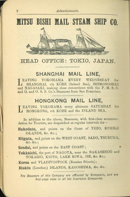
Advertisement from the Satow and Hawes guidebook, 1884 edition

Yoshino (accommodation at the house of Muramatsu Kichi-shi-rō; the quarters are poor, but the people are very obliging) Close to this village, the Jin-dzū-gawa is crossed by a kago-no-watashi.

This substitute for a bridge is constructed in the following manner. Four stout hempen ropes are secured to each bank of the river, at a point where it narrows and cuts its way between some fine rocks.Suspended to these ropes is a cradle of very simple structure, consisting merely of a plaited wicker circular bottom over which are bent two hoops made of tough branches crossing each other at right angles and firmly secured to the bottom. The ropes across the river pass under these hoops and thus the cage is hung.

Pole-bridge at the foot of the Abo Pass
Photo by H J Hamilton, in Walter Weston's Mountaineering & Exploration in the Japanese Alps

The cradle is hauled across by lines attached to it from either side of the river, and the method of crossing is to get into the cage and to be pulled over by men on the bank. Another way of crossing, and the one which is usually adopted by the peasant, is thus. He enters the cage, plants his feet firmly against the lower part of the hoops, leans well forward, and clasps the rope above him with his hands, and then by a series of jerks like the leaps of a frog, takes himself and the cage across to the opposite side. It requires great practice to be able to perform this antic, and at the same time good nerve is indispensable.

The main point seems to be not to lose the hold with the feet; the jerk is performed from the knee and hip, and unless great care is taken an inexperienced person may find himself hanging from the rope with the cage left behind him.

Fine masu (salmon-trout), weighing from 4 to 8 lbs., are taken in the river. A four-pronged spear, which fits into a staff having a stout line attached to it, is used for catching these fish. Ai and iwana are also taken by netting. The seasons for fishing are the end of spring and the beginning of autumn.

References

Excerpted from Ernest Mason Satow, CMG, and Lieutenant A G S Hawes, A Handbook for Travellers in Central & Northern Japan: Being a Guide to Tōkiō, Kiōto, Ōzaka and Other Cities; the Most Interesting Parts of the Main Island Between Kōbe and Awomori, with Ascents of the Principal Mountains, and Descriptions of Temples, Historical Notes and Legends, London, John Murray. The link leads to the 1881 edition, but the text above comes from the 1884 edition.