Thursday, October 27, 2022

The head-hunters of East Greenland

“We can be satisfied with our scientific results…” wrote the Swiss meteorologist Alfred de Quervain in 1913, a year after leading the first expedition to cross Greenland’s ice cap from west to east. And regarding Greenland’s weather, geography and glaciers, there was every reason to be proud of their findings. Indeed, climate scientists still refer to them today.

A plate from Hans Hössli's paper on craniological studies

When it comes to craniology, though, could it be that a chill creeps into de Quervain's tone? The expedition doctor, Hans Hössli, had assiduously investigated the physiology of Greenland’s indigenous people. But his research gets but the briefest of mentions in Quer durchs Grönlandeis, the popular book about the Greenland adventure that de Quervain published in 1914:

In another field, our anthropological measurements and collections added some welcome information, especially about the usually inaccessible east coast. The data on the craniums of the pure Eskimo race are particularly valuable, and are already being evaluated elsewhere.

To find out more, one needs to delve into the stacks of Zurich’s Zentralbibliothek. There, with luck, can be retrieved a yellowing copy of Ergebnisse der Schweizerischen Grönlandexpedition = Résultats scientifiques de l'expédition suisse au Groenland: 1912-1913. Published in December 1920, this is the volume in which, a world war after they returned to Switzerland, the expeditioners set down their scientific results for posterity.

Towards the back of this tome is the chapter by Dr Hans Hössli MD. The illustrations give the game away, as do the accompanying tables of figures. This is an exercise in measuring people’s skulls, particularly those of people living on the “usually inaccessible” east coast of Greenland.

But why bother? The clue here is found in the chapter’s introduction. The 1912 expedition, it explains, continued work undertaken on de Quervain’s first expedition to Greenland, in 1909. Footprints, hair samples and “body measurements” were collected from both the east and the west coasts. The work was carried out with the knowledge and approval of “Prof. Schlaginhaufen”.

Otto Schlaginhaufen in 1914
(Wikipedia)
Now the picture starts to come into focus. Under Otto Schlaginhaufen (1879–1973), the University of Zurich had become a world centre of research into the physical differences between races. Carrying on the work of Rudolf Martin (1864–1925), Professor Schaginhaufen presided over the university’s Institute of Anthropology from 1911 to his retirement in 1950.

As he saw it, Schaginhaufen’s mission was nothing less than to establish anthropology as a hard science – in contrast to the school epitomised by Franz Boas (1858–1942) in the United States, whose approach tended more in the direction of a cultural or social science discipline.

A hard science needs to draw on hard data. To that end, Schlaginhaufen and his followers sought to define the world’s peoples in terms of their physical dimensions – rather than in terms of “soft” factors such as differences in language and culture. As this required an internationally standardised approach to collecting such data, the Zurich school of anthropology drew up a whole apparatus of definitions and even specialised tools for measuring, say, the dimensions of a human skull.

This helps to explain Dr Hössli’s special interest in collecting skulls from grave sites on the eastern coast of Greenland. In this remote, less inhabited region, he postulated, one would be more likely to find examples of the “pure Eskimo race”, uninfluenced by intermarriage with European or American interlopers, as was commonplace on the island’s more populous west coast.

And it was for this reason, after arriving at Angmagssalik in August 1912, that he made a special trip to small islands south of the settlement. In this, he was accompanied by fellow expedition members Roderich Fick and Karl Gaule plus an interpreter. Excavating ancient graves, presumably without objections from any living inhabitants, the party added 28 more skulls to the doctor’s collection, supplementing the eight he’d already received from a Pastor Rovsing.

As Dr Hössli proudly notes, this was the largest series of skulls so far collected by any western researcher in Greenland, at least from a single site. And then:

We carefully collected the skulls, packed them painstakingly and took them to Europe. At the Anthropological Institute of Zurich, I was given the opportunity to measure and describe the skulls by the kind courtesy of Prof. Schlaginhaufen. The result of this work is presented in the following report….

In the 1920 report, several pages of data follow, together with illustrations of both skulls and live subjects. And with what results? Summing up, Hössli feels confident in dismissing previous commentators (“DAWKINS, BRINTON, LUBBOCK etc”) who posit a European origin for the natives of Greenland. Rather, he continues:

… we are firmly convinced that the Eskimo are of Mongolian descent, or since the term descent usually expresses a more recent condition, that they represent a basic Mongolian type. Whether this people had its homeland in Asia or North America is irrelevant for us in the first instance. What matters for us is to enquire how this Mongolian type is related to the recent Mongols of Asia.

And the chapter concludes with a compliment to the Danish authorities for their enlightened policies:

Finally, at the end of our work, we should not fail to remark the exemplary way in which Denmark has proceeded, especially in Angmagssalik on the east coast of Greenland, in terms of a colonialism that aims for the natural conservation of a race (“ganz im Sinne eines Rassennaturschutzes”).

“Rassennaturschutz”: a century after they were set down, words like these resonate uneasily. Even in Hössli’s day, some could foresee how such findings might be abused. As early as 1900, Professor Martin, Schlaginhaufen’s predecessor, had warned in his inaugural speech against the growing tendency for anthropological findings to be exploited for nationalistic or political ends.

History doesn’t relate what Alfred de Quervain really thought of his doctor’s anthropological investigations, except perhaps for that hint of faint praise in his expedition write-up. But an additional clue might be extrapolated from the plate from Hans Hoessli’s chapter, as shown at the top of this post. The portrait photo shows a hunter by the name of Kitsigajak.

"Old Kitsigajak" as shown in one of the expedition's hand-coloured slides
Image by courtesy of the ETH-Bibliothek

Kitsigajak gets several mentions in de Quervain’s book. He organises the final stage of de Quervain’s sea journey to Angmagssalik, as local people helped to bring the expedition back to human habitation on the east coast. And, in his younger days, he once paddled his kayak two thousand kilometres to southern Greenland and back to buy tobacco. And, finally, he anchors one of the expedition’s most important findings:

To us Greenland was a wondrous revelation. Among the insights which we – or at least I myself – gained is an awareness that the maxims that our civilization takes for granted, namely “faster and faster” and “more and more”, have in fact made fools of us. Do we believe that the quality of our lives is improved tenfold by going ten times as fast, or by hearing and doing ten times as much every day? …. Well, I wonder if that is really the case. For we have now arrived at a limit, beyond which the immutable law of our being will always have their way. That is, if sensations reach us ten times faster, their impression will diminish tenfold, with the result that the faster we live the more impoverished we will become. That is a small truth I have learned from the ice cap, from the midnight sun and the hundreds of little wrinkles in old Kitsigajak’s face. It is another of the results of the expedition that I may not suppress.

For de Quervain, Kitsigajak was an individual, not a specimen. And the Swiss expeditioners knew that they owed much of the success of their Greenland crossing, and probably their lives, to the indigenous techniques, tools, clothing and competence that they'd wholeheartedly adopted.

References

Pascal Germann, «Zürich als Labor der globalen Rassenforschung: Rudolf Martin, Otto Schlaginhaufen und die physische Anthropologie, 1900-1950», in Patrick Kupper, Bernhard Schär (eds), Die Naturforschenden: Auf der Suche nach Wissen über die Schweiz und die Welt 1800–2015, Hier und Jetzt Verlag, 2015.

Alfred de Quervain, Across Greenland's Ice Cap: The Remarkable Swiss Scientific Expedition of 1912, with an introduction by Martin Hood, Andreas Vieli and Martin Lüthi, McGill-Queen's University Press, May 2022.

Alfred de Quervain and Paul-Louis Mercanton, Ergebnisse der Schweizerischen Grönlandexpedition. 1912–1913 (Neue Denkschriften der Schweizerischen Naturforschenden Gesellschaft, Kommissionsverlag von Georg & Co., Basel, 1920.

Saturday, October 22, 2022

“We tried dogmeat on occasion…”

How the 1912 Swiss expedition geared up for the first west-to-east crossing of Greenland's ice cap (translation of the expedition leader's notes) 

While the book was being printed, I was several times asked to include in this publication some details of our technical equipment, as our success depended on its thorough preparation. Some of this information is included in the popular account of our expedition, Quer durchs Grönlandeis, and our expedition member Dr H. HOESSLY has independently published a review of "Polar expeditions and their equipment” in the Schweiz. Skijahrbuch (1913), which is essentially an outline of our expedition’s technical gear and our experiences, as originally intended for this volume.

"Encampment of the traverse party on the inland ice
with sledges and dogs, after the snow storm"
(photo and caption as published in the original report)

It remains only to add that our equipment was essentially collected and prepared by the undersigned expedition leader, based on the experience of his journey to the inland ice in 1909 (together with Dr A. STOLBERG and Dr E. BAEBLER), and with the support of the expedition members R. FICK and K. GAULE in the provision of some specially manufactured items, such as tents and sled equipment. H. HOESSLY, in conjunction with my brother Prof. F. DE QUERVAIN, provided the medical equipment. He also served as our “quartermaster” on the trip. My wife also undertook a large share of the work on the equipment.

1. Rations.

The following was our daily ration on the inland ice: pemmican 200 grams (mixture 50% meat powder and 50% fat, and hence a relatively fatty mixture, as recommended to us by SHACKLETON, and produced by BEAUVAIS (now known as the Danske Vin og Konservenfabrik) in Copenhagen, which was consumed mostly as soup mixed with vegetables. Bread 200 grams (as dry ship’s bread, rusks, cakes). Soups 50 grams (dry vegetables, Maggi soups). Sugar 100 grams (as honey and preserves, apple slices). Butter 40 grams (salted Danish butter). Chocolate 50 grams (pure, or meat chocolate, enjoyed while travelling). Cheese 30 grams. Milk (condensed, sweetened, thick or powdered, from Cham, Glockental and Stalden (Switzerland). Meat 100 grams (canned from Lenzburg and Rorschach (Switzerland), smoked meat, bacon. In addition, we tried dog meat on occasion. This was tough and offputting, but successful enough as an experiment. To drink: coffee, tea or milk (no alcohol). 

Producers of pemmican: advertisement for the Beauvais company
Image by courtesy of Wikipedia

The total weight, about 900 grams, seems small as compared with the rations of other expeditions. For us, it was quite enough; some of our members who kept eating the full pemmican ration after we arrived on the east coast returned home having put on a noticeable amount of weight. In general, our rations worked out well: we would not change anything, especially the pemmican. Although other expeditions have described it as unpalatable and a necessary evil, we all took to it most warmly and we have missed it since. Indeed, we have used it as the best conceivable food for alpine climbs and recommend it unconditionally.

Feeding the dogs. 350–400 grams of pemmican (allowing for all eventualities, following O. NORDENSKJÖLD'S example, whose pemmican was mixed in the same proportions as ours). In addition, for the first few days, a handful of small dried fish for each dog, during the transition period. This food sufficed; towards the end of the crossing, some dogs got diarrhoea, perhaps from consuming the meat of their companions, as some of the less fit animals had to be slaughtered and fed to the others for efficiency’s sake. (HOESSLY thought that the slaughtered dogs were suffering from muscular tuberculosis).

Meal times. Two hot; after arrival at campsite, pemmican soup, after sleeping, milk etc with supplements. While travelling, short stops to eat; warm drinks from thermos bottles (as long as they stayed intact). Dogs were fed once a day, immediately after arrival; afterwards, their muzzles were tied shut.

A Nansen stove in use by Captain Scott's expedition, 1911
Photo by courtesy of Royal Geographical Society (copyright) 

Cooking apparatus. Nansen stove, with outer jacket and lidded vessel, as produced by The London Aluminium Company, with a Primus petrol stove. The petroleum supply amounted to 30 litres (in various containers in special compartments distributed between the sledge boxes!), of which 8.5 litres were used on the inland ice, which was enough to provide four men with plentiful warm food and drinks for two daily meals (by melting firn snow!) for four weeks. To melt water in case of emergency, a large, thick, black cloth with pockets with snow-filled pockets could be hung on the sunny side of the tent: this produced sufficient meltwater when we tried it out at our highest camp on the ice sheet.

2. Sledges and tent equipment.

For the four expedition members, three Nansen sledges (leaving one man free to go on ahead), from the firm of L. H. Hagen, Christiania, each four metres long, with guardrail and thin steel plate flooring. On the front of each sledge (driver’s seat) was affixed a light limewood box sized and strapped to the sledge, with light fittings for instruments, cooking utensils etc (matches were soldered into tins!). Three or four bags were strapped onto each sledge (those for sleeping bags and clothes must be waterproof).

Nansen sledge with sail, at Holstensborg, May 1912

Tent made of gray-green military tent fabric, to shade the eyes and for heat absorption, main floor space rectangular: 2 x 2.50 metres, with a wedge-shaped projection opposite the entrance, which was pitched against the wind. Shape roof-shaped, ridge height 1.70 metres, supported by four bamboo poles, which ended in cloth caps at the top, and were inserted into 15-centimetre long canvas pockets at the bottom to prevent snow and mosquitoes from entering, and attached inside the tent. Ridge with strong rope sewn in, to keep it taut in a storm. Tent entrance made of light fabric, tube-shaped, which could be tied off from the inside. Tent floor integrated with the rest of the tent; inside, the floor was covered with a completely waterproof sheet, which could also be used as a sledge sail, in conjunction with the tent poles, which fitted together as a mast and yards with the help of some rings and fitted cords. For sailing, two sledges were run side by side.

3. Clothing.

Thick woollen clothing (heavy Graubünden loden proved its worth), woollen undergarments, single or double; three each, to change. Warm woollen cap (with the wind always blowing against us, insufficient forehead protection caused permanent discomfiture). In snowstorms, overgarments of light, dense Burberry fabric; welcome some of the time; also for occasional sleeping in the open. For static surveying work at camps in the cold and for longer sledging trips: cloth jackets and hoods lined with South Greenland bird down (anoraks), high double fur boots (kamiks, with seal-skin outers, lined with dog fur). Otherwise, for use with the skis: Laupar boots, only lightly nailed, but used on bare ice with well-fitted crampons. Ash skis with Hvitfeld bindings; the bases of one pair with an awkward grain direction ended up quite rough. Three-metre langlauf-type skis, taken as an experiment, were too fragile and unwieldy when working with the dogs.

The traverse party taking a break (Fick, de Quervain, Hoessli)

In the tent, we had four single sleeping bags of young reindeer (winter) fur, weighing about 5 kilograms, which obviously would have sufficed for much lower temperatures.

Against the sun's rays, we were equipped with goggles made of yellow glass, which keeps out the ultraviolet and blue-violet rays without otherwise noticeably reducing the brightness. Thanks to the timely use of glacier ointment (Glacialin, Zeozoon), we hardly suffered from the sun’s effect on the skin, except for the lips; abundant beard growth proved helpful. For the dogs, I had 60 “dog bootees” made, in order to prevent their paws from being abraded on the hard, bare and jagged glacier ice. These found occasional use on the western margins of the ice cap; fortunately they were not needed for long. With each sled, there was a 25–30 metre glacier rope. We had all the necessary material with us, as well as the necessary technical skills, to repair or remake the dog harnesses, which were often devoured by their wearers.

Lead dogs of the team, Silke and Mons (?)
Greenland inland ice, June/July 1912

To learn how to drive the dogs, we underwent a thorough apprenticeship of several weeks with the Greenlanders of the west coast (in Sarfanguak and Kuk near Holstensborg, under DAVID OHLSEN) in order to learn, if not the art, then at least the ability to safely handle and manage the 30 dogs we acquired by prior arrangement in Egedesminde, Akugdlit and Jakobshavn. This capability was almost the single most important item of our equipage. The party working on the western edge of the inland ice lived under similar conditions; only their equipment had to be lighter because they couldn’t use dog sledges to help make the often laborious portages, and it could also be lighter because of the warmer temperatures (their tent was made of raw silk, which was inadequate in heavy rain; the sleeping bags made of canvas with flannel linings and with air cushions would have sufficed if they had been properly manufactured). Also, whenever they were not moving, the members of the western party used Greenlandic clothing (ie the hooded Greenlandic "anorak"), which they often still favour for alpine excursions.

(Undersigned)

A. DE QUERVAIN

References

The above note appears in Alfred de Quervain and Paul-Louis Mercanton, Ergebnisse der Schweizerischen Grönlandexpedition. 1912–1913 (Neue Denkschriften der Schweizerischen Naturforschenden Gesellschaft, Kommissionsverlag von Georg & Co., Basel, 1920.

Copy of original report and accompanying images provided by kind courtesy of the ETH-Bibliothek, Zurich. 

Quer durchs Grönlandeis, Alfred de Quervain’s book about the expedition, has recently been republished in English as Across Greenland's Ice Cap: The Remarkable Swiss Scientific Expedition of 1912, with an introduction by Martin Hood, Andreas Vieli and Martin Lüthi, McGill-Queen's University Press, May 2022.

Monday, October 17, 2022

The long-dated legacy of Dr Wilhelm Jost

On 18 July 1912, the “western party” of the Swiss expedition to Greenland had a close call. Seeking a way back over the wildly crevassed Eqip Sermia glacier, the young physicist lost his footing in a meltwater channel and slithered towards a lurking sinkhole. Moments before vanishing into oblivion, he was able to jam his spiked footgear into the water-slicked ice. Wearing crampons, still thought of as new-fangled, had saved his life.

Wilhelm Jost (seated, right) with other members of the
"western party", Quervainshavn, June 1912

All kinds of innovation intrigued Wilhelm Jost (1882-1964). We’ve already met him as a pioneer of colour photography in the polar regions. He was a trail-breaker in his mountaineering too, having climbed with the Academic Alpine Club of Bern, which promoted the controversial practice of mountaineering without professional guides. In Greenland, by fusing these talents, he made a solid contribution to the Swiss expedition’s rich and varied photographic legacy.

Most importantly, Jost served as the guide for his two companions, who relied on him to find a safe path through the ice-fields they were surveying. “Jost never loses his guiding instinct; carefully but decisively he hacks steps, detours or jumps over crevasses. What an alpinist!” applauded Paul-Louis Mercanton, the team’s leader, in his memoir of that summer.

Crevasses on the Eqip Sermia glacier, Greenland 1912

In other ways, though, Jost was a traditionalist. Born on a farm in the Wynigerberge hills near the Swiss capital city of Bern, he stayed in close touch with his home village throughout his life. And he kept the bluff, direct manner of rural Switzerland too, even if– his obituarist hastens to add – his speech was “never crude”. When it came to his work, he liked to say – in his rugged Bernese dialect – “Es wird nüt halb gmacht, aber o nid gschlärpelet” – it won’t be done by halves, let alone shirked.

Nobody shirked their duties in that “western party”of the Swiss expedition. In June 1912, they helped their leader Alfred de Quervain and his companions port their sledges and gear from the beach up onto the ice cap, a sweaty and mosquito-plagued task. Then, while the so-called eastern party went on to make the first west-to-east traverse of Greenland’s ice cap, the western party returned to the coast and started their own research programme.

Ice front of the Eqip Sermia glacier, summer 1912
Photo by Wilhelm Jost

Encamped in a leaky tent and ceaselessly harassed by the voracious midges, the trio of scientists spent the rest of the summer surveying the enormous Eqip Sermia glacier, which de Quervain had chosen as his access ramp to the ice cap. Here the party supplemented traditional surveying techniques with another new discipline – that of stereo-photogrammetry. For this purpose, Jost lugged a heavy 13 x 8 format camera across the fractured ice sheet and its rugged foreland.

After Professor Mercanton went home in the autumn, Jost removed to Disko Bay, together with August Stolberg, a meteorologist. Based at a permanent research station, they launched weather balloons and instrumented kites through the arctic winter. Most of the balloons were tracked by theodolite to a few kilometres or so before bursting or fading into the cirrus clouds, but one soared to the staggering height of 39,000 metres before the meteorologists lost sight of it.

Launching a weather balloon at Godhavn, spring 1913 (?)

At Christmas, the scientists caroused with the local Greenlanders. While they toasted each other with many a small glass of ‘snapsemik’ (caraway-flavoured schnapps), Jost entertained the company in his “beautiful baritone voice”. In his spare hours, he joined the Greenlanders in fishing for sharks through holes cut in the sea-ice – the livers were prized for their oil. Unsurprisingly, the Swiss duo left a lasting impression on their hosts, as Stolberg recounts in his essay on their winter sojourn:

As an expression of astonishment – as we might say ‘holy smoke’ – it became the fashion in Godhavn to simply say ‘Stolberg’ and later ‘Jost’. A man like Jost, who could stash a 75-kilogram hydrogen cylinder under each arm was something else altogether. I wonder whether ‘Jost’ was incorporated in a later edition of the Greenlandic dictionary, in the same way as the favourite expression of the Hutterite missionaries “Ach, ja so” (= oh, really!) is preserved in the verb ‘ajasopok’ meaning ‘to be astonished’.

Back then, the greatest astonishment in scientific circles was probably reserved for the western party’s weather data. Their balloon observations showed that Greenland’s winds blew in a variety of directions during the winter – hence exploding a popular theory that called for a stable circulation of air around the polar regions in that season.

Today, by contrast, it is the trio’s glacier survey that still draws attention. In 2018, two Swiss glaciologists, Andreas Vieli and Martin Lüthi, resurveyed the Eqip Sermia to see how the glacier has fared since 1912. Their findings “support the view that the Greenland ice sheet was roughly in balance for a century or more before the onset of today’s rapid mass loss”. This suggests that Greenland’s ice started to melt at the current catastrophic rate only in the last few decades, a finding that should redouble our concerns about the pace of climate change.

Back in Switzerland, Dr Jost resumed his career as an educator. From 1917 to the end of his career, he taught physics at the Realschule of the Städtisches Gymnasium, in Bern, an elite high school. But he kept in touch with the ice too. After joining the Glacier Commission of the Schweizerische Naturforschenden Gesellschaft – the scientific association that had endorsed the de Quervain expedition – he succeeded in making the first seismic ice depth measurement on the Rhone glacier, with Max Oechslin and other geophysicists. This was in 1931.

Four years later, he brought the same technique to the Unteraargletscher – the very same ice-stream that Louis Agassiz had started to investigate a century before, thus founding the discipline of glaciology. These investigations continued for a further six seasons, helping the researchers to profile the glacier’s ice mass and its rocky bed. Jost wrote up his findings in a series of papers which, one day, he meant to feed into a magnum opus on glacial research.

The Unteraargletscher c.2010
(Image by courtesy of Alpine Light & Structure)

Work on the great monograph advanced, if at all, at a glacial pace. For Jost was always a busy man: during the second world war, while continuing to teach, he served as the president of the Schweizerische Naturforschenden Gesellschaft for two years and, at the same time, commanded a battalion of the Swiss Army.

Retiring from the Realschule in 1952, he spent his last years at home, keeping in touch with colleagues and taking pride in his son, daughter and grandchildren. These sunny last years were overshadowed only by the early loss of his beloved wife.

The Rhone Glacier in 1912
Courtesy of the State Archives of Canton Bern

As for the magnum opus, it never did appear. In its place, though, Jost had already dispatched a longer-dated message to the future. In 1928, working with Max Oechslin and Professor Mercanton, his colleague from the Greenland expedition, he sealed “contemporary documents” into empty shell or grenade casings and dropped them into crevasses on the upper reaches of the Rhone Glacier.

At the time, these impromptu time capsules were expected to reach the glacier’s foot at some point in the twenty-second century. But this, of course, was to reckon without the accelerated melting that has recently transmogrified the glacier’s front into a large lake. One way or another, the ice may deliver Dr Jost’s last testament rather sooner than anticipated.

References

Alfred de Quervain, Across Greenland's Ice Cap: The Remarkable Swiss Scientific Expedition of 1912, with an introduction by Martin Hood, Andreas Vieli and Martin Lüthi, McGill-Queen's University Press, May 2022. The reminiscences about Wilhelm Jost in Greenland come from the two additional chapters, by his western party companions, Paul-Louis Mercanton and August Stolberg.

H. Adrian, obituary for Wilhelm Jost 1882–1964, Mitteilungen der Naturforschenden Gesellschaft in Bern, vol 22, 1964 (German language).

Wednesday, October 5, 2022

Arctic dreams in Autochrome (2)

Continued: the chequered origins of polar photography in colour

... Alas, Captain Scott was not impressed. In his journal entry for 25 April 1911, he wrote that “Ponting has taken some coloured pictures, but the result is not very satisfactory and the plates are much spotted”. There was nothing personal in this judgment, by the way. On Scott’s previous expedition in 1901–04, his surgeon Reginald Koettlitz had produced the first colour pictures ever made in Antarctica, using an even more laborious method than Autochrome. But these too were rejected for publication.

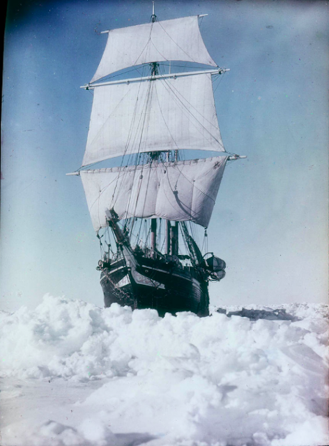
A colour picture of the Endurance by Frank Hurley, 1914-15
By courtesy of the State Library of New South Wales (via Wikipedia)

Another contender for Best Polar Colour Image of the Belle Époque was Frank Hurley. Accompanying Ernest Shackleton on his aptly named Endurance expedition (1914-17), the Australian photographer made a number of colour images of the expedition’s ship stuck fast in the ice. He used a process marketed by the Paget Prize Plate Company, a would-be rival of the Autochrome. When the expeditioners had to abandon their ice-shattered ship, Hurley thought well enough of the results to take some of these images with him. But the photographs that made his name are all black-and-white.

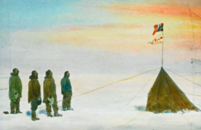
The fact is, Captain Scott was right. As a way of efficiently representing the world in colour, neither the Autochrome nor the Paget process was ready for prime time. Indeed, Scott’s rival and nemesis, Roald Amundsen, had no truck with it. In his race for the South Pole, in late 1911, the Norwegian explorer didn’t even bring along the expedition’s large-plate camera. This left his sledgemate Olav Bjaaland (1873–1961) to document the journey with his amateurish Kodak 3 x 3, in plain black-and-white.

Amundsen's expedition at the South Pole (hand-tinted slide) 
Image courtesy of the Fram Museum, Oslo

After his return to civilisation, Amundsen may have had cause to regret this photographic parsimony. Slide lectures, which were critical for defraying the costs of an expedition, depended on good imagery. And colour would make the images yet more compelling. The Norwegian explorer made up this deficit at his first homeward port of call. Taking the expedition’s negatives to a local photographer in Hobart, Australia, he had them made into hand-coloured glass positives. More were produced later. Not everybody was impressed. Scott’s widow, Kathleen, who went to one of Amundsen’s lectures, thought the hand-coloured slides looked ‘faked’.

Like Amundsen, the Swiss expeditioners were left with substantial debts to repay after their return to Zurich in the autumn of 1912. And, whether or not they actually knew of Amundsen’s gambit, they ultimately followed in his photographic footsteps.

Hand-tinted glass slide of Inuit children, by Arnold Heim
Courtesy of ETH-Bibliothek, Zurich

Probably, it was the Swiss geologist Arnold Heim (1882–1965) who actually showed them the way. On his way to inspect mineral deposits in Disko Bay, Heim had travelled with Alfred de Quervain on the latter’s first trip to Greenland in 1909. Together with the botanist Martin Rikli (1868–1951), Heim wrote up his trip in a popular book that came out in 1911. It was illustrated with hand-coloured photos showing the island’s inhabitants and landscapes.

Landscape in Greenland by the Swiss 1912 expedition
Courtesy of the ETH-Bibliothek, Zurich

In the end, none of the 1912 expedition’s Autochrome plates appeared in de Quervain’s book, except for that lone frontispiece. Instead, he took the black-and-white images to Wilhelm Heller, a professional retoucher working at Sumatrastrasse 3, Zurich, and had them hand-coloured. 

Igner Ohlsen: the hand-painted glass slide version
Courtesy of the ETH-Bibliothek, Zurich

One of these was the image of Igner Ohlsen that was eventually to appear in de Quervain’s book (above). She looks notably more relaxed in the hand-coloured version, which probably reflects the shorter exposure time for a black-and-white picture.

As Heller had never been near the Arctic, he had to take his colour cues from de Quervain’s instructions. In this sense, the resulting lantern slides are tricked out in the very hues of memory itself.

References

Alfred de Quervain, Quer durchs Grönlandeis, 1914, now available in translation as Across Greenland’s ice cap, McGill-Queen’s University Press, May 2022, with more than sixty colour images from the expedition.

Patricia M Millar, "Filtering ‘ways of seeing’ through their lenses: representations of Antarctic exploration by lesser known Heroic Era photographers", MSc thesis, University of Tasmania, 2013.

Tamiko Rex, South with Endurance: Shackleton's Antarctic Expedition 1914-1917 ( the Photographs of Frank Hurley), BCL Press, January 2001.

Liz Watkins, “Mapping the Antarctic: Photography, colour and the scientific expedition in public exhibition”, Chapter 24 in Lindsay W MacDonald, Carole P Biggam, Galina V Paramei, Progress in colour studies. cognition, language and beyond, John Benjamins Publishing Company, 2018.