Monday, December 26, 2022

A meizanologist's diary (42)

9 November: after circling Narita airport, the Boeing takes up a northeasterly course out across the Pacific. Surely this can’t be the way back to Europe? Nobody announces anything – heck, we’re just px – and for a moment I wonder if I’ve boarded a flight to Seattle instead of Zurich. 


Then I get it. The next-best way back to Europe, if geopolitical factors obtrude, is over the North Pole. And so it turns out. We make a beeline, or more probably a great circle route, directly for the Bering Straits. Before we get there, the light fades through an abbreviated afternoon into an accelerated sunset. Then we turn due north, hugging the Alaskan coast.


In the event, we skirt the North Pole itself by some hundreds of kilometres. A little later, the polar night lightens enough for a long dark rift to appear in the undercast below – no, that’s not cloud but a lead of dark water in the drifting ice pack. The glimpse recalls Fridtjof Nansen’s Fram expedition, on a ship that was designed to drift across the arctic embedded in the pack-ice.

Of course, Nansen didn’t quite make it to the pole either, giving up his bold foray from the ship at 86 13.6′ North in April 1895. But what a vintage year for exploration that was. In August, Alfred Mummery vanished into thin air, in an attempt to ascend Nanga Parbat that was about a century before its time.

And in December, the meteorologist Nonaka Itaru and his wife Chiyoko were rescued from their pioneering midwinter sojourn on top of Mt Fuji. They too were far ahead of their era, for nobody else would attempt to emulate their feat until well into the following century.


The thought of that icy vigil prompts me to look at the flight display again – as we approach northeastern Greenland, the outside air temperature falls to minus 63⁰C. Not to worry, though, we should still have a few degrees in hand before the jet fuel starts to freeze. Now that really would be yabai....

Sunday, December 11, 2022

A meizanologist's diary (41)

9 November: Narita, 6am: as it’s too early to head to the airport, I head in the other direction, towards the eponymous temple. After all, folk refer to it as “Narita-san” (Mt Narita), hinting at something of meizanological interest. 


The old street winds away between souvenir shops, galleries and restaurants offering various renditions of eel – as favoured by old-time pilgrims from Edo, according to the helpful brochure I picked up in the hotel, to strengthen their knees.


Strengthening your knees might be a good idea. The countryside here may look flat from a passing airliner but, like Kent or Kentucky, the landscape actually ripples away into wolds and swales (not the local words for them, of course). 


Thus would-be visitors to Shinshō-ji, as the temple is formally called, must first scale a steep and sustained flight of stone steps. Fortunately, a fine rock garden provides an excuse for tarrying at half height.


At this hour, of course, actual visitors are few. But a chrysanthemum exhibition and a poster advertising the shichi-go-san ceremonies underline that this is a busily working temple with a full yearly calendar, not a tourist trap for passing travellers. But still I wonder what the deal is with this temple’s “mountain” suffix.


The answer comes from a straw-hatted pilgrim, or rather a bronze statue of one. No, not just a pilgrim, but the Daishi himself, the monk who – says H Byron Earhart in his  magisterial book on Mt Fuji – most radically altered the trajectory of Japan’s mountain religions.

Before Kōbō Daishi, mountains were themselves the objects of worship. But Kūkai, as he was also known, saw them more as places of spiritual retreat. “According to the sutra, meditation should be practised preferably on a flat area deep in the mountains … for the benefit of the nation and those who desire to discipline themselves,” he wrote.

And so, to this day, temples of the Shingon sect that Kūkai founded are known as "mountains", often including the character for 'yama' in their names. I should have guessed - we've visited such a "mountain temple" before.  


In fact, Shinshō-ji was founded by a disciple of Kūkai, not the Daishi himself. But the master's spirit seems to have faithfully imprinted itself on this far-flung outpost of the Shingon sect. I’m now wandering up another flight of stone steps towards the temple’s highest walks, which are surmounted by a “peace pagoda”.


Is it my imagination, or do the gardens take on a wilder character here, as if recalling the magnificent cryptomeria forests that surround the founder’s monastery on Kōya-san? It seems I’m not the only one to think so. This writer captures their atmosphere perfectly:

The natural Nature which is apt to be forgotten carelessly. Something recalling me to this is left in the Naritasan park. The park overflows in the trees and plants and Nature, and thought to respect all life of the thing which straight of the Buddhism arranges is incorporated …When the stairs near the light temple in the precincts are gone down, a waterfall of the donation that light comes in from a grove turns up from a huge rocky mountain…”

The light of a late autumn sunrise is starting to slant in over the groves. It is time to go down the mountain. In front of the Daihondō, a gardener is filling his watering cans for the daily round. “What splendid gardens,” I say as I pass, and he smiles. At Narita-san, natural Nature is in no danger of being forgotten carelessly.


Friday, December 2, 2022

A meizanologist's diary (40)

5 November, 6am: frost pillars, as wished for yesterday, heave obligingly out of the soil as we tackle the steep hill behind the hut. Fixed ropes help us to pull over greasy steps. At least there are no more slippery tree roots to stumble over, now that we’ve left the treeline. And the packs are lighter, as our bivvy gear has stayed at the hut.


We’re climbing the Pitch of the Beautiful Women (美女坂), observes the Sensei gleefully. Gaining height, we haul the Northern Alps into view over the intervening ridges – there’s Yari silhouetted against a chilly dawn glow, and Tateyama too. The latter, another dormant volcano, is the only mountain other than Hakusan that has paths known as Zenjōdō. And, intriguingly, it also has a place named for Beautiful Women (美女平). It's as if the two mountains have been conversing for centuries over this aery gulf between them.


Now we start across a frozen marsh. The scenery is like a miniature Oze, except that the boardwalks are frosted; we tread them warily. The Sensei points to a lily’s skeleton; in early summer, this would be a meadow of nodding yellow blooms. That would more than justify its name of Flower Garden (花園).


After the Trial of the Boardwalks (nobody fell into the marsh), we start on a grassy traverse. Across the valley is Hyakuyojō-no taki(百四丈滝), a waterfall purporting to be no fewer than four hundred chains high. Lurking in the early morning shadows, it is heard more than seen; we will inspect it properly on our return, when the light is better.


Ahead the Sensei points out Ōnanji. As this peak serves as the oku-miya (inner sanctuary) of the Hakusan shrine, it should make a fitting endpoint for our passage over this Zenjōdō. It doesn’t look that far above us.


This misapprehension is corrected when the traverse path drops away in front of us. As it would be too demoralising to lose a hundred metres of height all at once, we sit down on a boulder of pitted lava – a discreet reminder of Hakusan’s volcanic origins – and refresh ourselves with the Sensei’s home-grown sweet potatoes.


The sun is now high enough to warm us on our lava pedestals, and the wind has dropped too. But over there on Ōnanji, a filmy mist starts to veil the summit. We take the hint not to linger. While we scramble down to the col, what started as a mere wisp of vapour congeals into a fully fledged cap cloud.


Zig-zags take us down to a col. Its fluttering expanse of panda grass is a lost world halfway between earth and sky. A small pond, Abura-ike, would charmingly reflect the travelling clouds, except that it has long since frozen over. Then the path tilts upwards again. A glance at the map shows us to have embarked on Nagasaka – the Long Slope.


If only the slope were just long. The path is now entrenched in a steep grove of creeping pine trees, which rake us with their ice-glazed fronds as we push through them. When we emerge from this Austerity of the Hoarfrost, we find that a fox has made off with our visibility. But, no matter, my altimeter says we’re within a hundred metres of the summit.

Altimeters, as I should have learned yesterday, are but fickle guides on a Zenjōdō. The Sensei knows better; this is her local mountain, after all: “If we don’t turn back now, we’ll be walking back down in the dark,” she says. But, heck, I object, it’s only ten and we’re nearly there. What if I run on ahead and see if I can get to the top in the next half hour?


My proposal is not endorsed, but neither is it vetoed. Taking this as an assent, I push on upwards into the freezing fog, giving myself an extra half an hour to make the summit. Soon it starts to dawn on me that we're not yet on the slopes of Ōnanji, but only on what the Swiss would call a “Vorgipfel”. Or, depending on how you read the map, just a Vorgipfel of the Vorgipfel ...

Doubt is already creeping in when I come to what looks like a fork in the path – if one of us went astray, we would never find each other in this murk. And what is the point of summiting without the Sensei? For shame, even to think of it. I turn back and, a few minutes later, I’m relieved to see her still coming up. “You're right,” I admit, “this is no weather for splitting the party.” 

Zenjō (禅定), an expert on the Tateyama religion explains, refers to a state of mind during meditation. Moreover, it indicates austerities or 'meditations' on sacred mountains. Just as we start down, the Kaga Zenjōdō presents us with another of its revelations. When the clouds lift, we see the whole ridgeway uncoiling below, like the crenellated spine of a dragon. In this vast landscape - I realise we haven't seen another soul for two days - the two of us suddenly look very small.


A similar feeling seems once to have assailed Arne Naess, the alpinist/philosopher who famously turned back before reaching the summit of a sacred peak in the Himalaya. In his essay on Modesty and the conquest of mountains, he wrote that “The way is such that the smaller we come to feel ourselves compared to the mountain, the nearer we come to participating in its greatness,” before adding enigmatically, “I do not know why this is so.”


It takes a long time to retrace our steps. All too soon after we pick up our kit from the bivouac hut, the lingering clouds turn gold. In the fading light, those slippery tree roots send me sprawling more than once. The Sensei was right about turning back on time. The last zig-zags down to the valley must be illumined by the light of our headtorches. Walking back to the car, along a forest track, we wade through pools of moonlight so bright they seem almost to buoy us up. 


Friday, November 25, 2022

A meizanologist's diary (39)

4 November: from a nearby thicket reverberates a roar. Not your tentative, throat-clearing, osore-irimasu kind of growl, but the full-tilt boogie woogie, Metro-Goldwyn-Mayer r-r-roar of an apex predator. Less than an hour after starting, we seem to have disturbed a beast who resents our presence.


“Was that a bear?” I ask the Sensei, somewhat superfluously. “Probably,” she replies, sounding unimpressed, as if dealing with just another unruly pupil from her middle school teaching days. I am reassured: if that bear happens to be sporting a non-standard haircut, it will be ill-advised indeed to come out from that thicket.


Plodding on upwards under the dripping beeches, I start to see where the bear is coming from. For half a century, the animal – or its forebears – had this ridge to itself. The path for humans washed out in 1937 and wasn’t restored until the 1980s. Even today, it is far less frequented than the standard route up Hakusan, for reasons we will soon appreciate.

The bear has made its point. This is not a hiking trail. Rather, it is a Zenjōdō, a Way of Righteousness. And those who tread it will undergo various tests and tribulations until they reach some higher level of awareness. Or fall by the Wayside. The latter outcome can’t be ruled out, laden as we are by four or five litres of water, sleeping bags and cooking gear.


Hakusan, a sacred mountain, has three Zenjōdō, but the one we are attempting, from the Kaga side, is much longer and more rugged than the modern "normal route" from the west. We are heavily loaded because – unless we opt for trail-running – we’ll need to stay in the Oku-Nagakura bivouac hut, which is innocent even of a water source. The pack is starting to become a trial in itself.

At least the weather front has gone by, even if the clouds haven’t yet cleared. For November, it’s warm. “In the old days,” I observe to the Sensei, “you’d have seen frost pillars poking up out of the ground by now.” Always, people should be careful what they wish for.


We come up to a little shrine, shrouded in mist and watched over by a stand of evergreens – hinoki, says the Sensei, good for making storage chests. The girth and stature of these noble trees suggest what might have been if too many hadn’t been made into chests and temple pillars in centuries gone by.

The path levels out, stray sunbeams slant in below the drifting cloudwrack, and even our watch altimeters strike an optimistic note: they now read within a hundred metres of the hut’s altitude.


Alas, we are deluded: just as the digital readout says we are almost there, the path sinks away towards a deep col and, like pachinko players on a bad streak, we give up all of the last half-hour’s winnings. I recall reading somewhere that Hakusan is a “dissected edifice”. Naruhodo, like John Pierpoint Morgan’s stock market, this ridge will go up. And it will go down. But not necessarily in that order.


The hut is reached as the light starts to fade. The Sensei agrees that it’s been years since we’ve done anything like this. Nevertheless, she has the stove lit and the supper cooking before I have even managed to recombobulate myself. We slurp noodles by the light of our head-torches; I’d forgotten how quickly it gets dark in November around here.

Stepping outside after supper to address the bank of panda grass that fringes the hut, I find myself under a starry sky, Orion stretching up to the winter zenith, as he always did. The mountains have vanished into a void even darker than the sky, relieved only by the faraway strip of lights along the coastal plain. It’s going to be a cold night up here at 1,700 metres …


Thursday, November 17, 2022

A meizanologist's diary (38)

3 November: somewhere near Nagano, the morning Kagayaki goes to ground in a tunnel. And there the super-express skulks while the authorities work out where Kim Jong-un’s latest projectile is going to land. We arrive in Tokyo with half an hour’s delay.

From Shinjuku station, it is necessary to hurry through the badlands of Kabuki-chō to an office near Shin-Okubo. To be late for this meeting would be unthinkable, as the participants are risking a mostly “in person” meeting for the first time in months, if not years.


At 2pm, Dokiya-sensei calls us to order and the proceedings begin. The “Fuyō Nikki no kai” is dedicated to the memory of the meteorologist Nonaka Itaru and his wife Chiyoko, who sojourned on the summit of Mt Fuji in the winter of 1895 to make weather observations, holding out there for almost three months. Everybody at this meeting has some connection with this story, except perhaps for your blogger, who is merely representing the Sensei (otherwise occupied today).

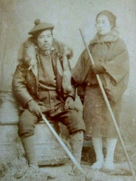
Nonaka Itaru and Chiyoko in mountain garb
(Photo by courtesy of the Nonaka Itaru & Chiyoko Digital Archives)

As for the “Fuyō Nikki” (Mt Fuji diary) itself, this was the title of Chiyoko’s journal, which she published in a newspaper the year after the mountaintop adventure. A full English translation is forthcoming (watch this space), based on Ohmori Hisao’s definitive joint edition of Chiyoko’s journal and Itaru’s “Guide to Mt Fuji” (Fuji Annai).

Ohmori-san’s “kaisetsu” (introduction) to that edition is the starting point for anyone interested in the Nonakas’ story – he mentions today that it was based on painstaking trawls for contemporary newspaper articles preserved on microfilm in the Diet Library, conversations with legendary figures in the history of Mt Fuji such as Fujimura Ikuo, and more than one foray to the mountain in winter. Indeed, to fully appreciate the magnitude of the Nonakas’ achievement, it helps to have experienced Mt Fuji in full winter conditions.


All this happened a long time ago, yet new details of the Nonaka story are still coming to light – for example, that the Japan Meteorological Association almost certainly admitted Chiyoko to its ranks, showing that Meiji-era scientists might have held remarkably progressive attitudes, at least in this case.

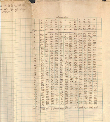
Summit weather readings from November 1895
(Photo by courtesy of the Nonaka Itaru and Chiyoko Digital Archives)

Across the table, Yamamoto-sensei puts up a slide of the cloth-bound ledger in which Itaru and Chiyoko recorded their weather observations in a neat copperplate hand – amazingly, these records have survived in good condition. No less remarkably, the ledger shows that temperature and barometer readings were set down every two hours, night and day, throughout the twelve-week stay on the mountain – only the wind speed data are incomplete, as the anemometer broke down along the way.


Sadly, no trace of the Nonakas’ tiny summit hut remains. Nakayama-sensei, who also runs the association’s website, brings out a paper model of the present summit station, which was constructed in the early 1960s, and shows us that one of its outlying buildings must have obliterated whatever remained of the Nonakas’ refuge. Oh dear, I’d hoped to find some relics one day.

In Japan, Itaru and Chiyoko have been celebrated – mainly for their exemplary “gaman” – in a stage play and a full-length movie, as well as several novels and two TV dramas. The story has seeped out into the English language too, first via contemporaries such as Lafcadio Hearn and latterly through at least one scholarly article and a recent feature in Alpinist magazine.

After being rescued from the frozen mountaintop in December 1895, Nonaka Itaru never did manage to build a bigger and better weather station, as he’d intended. For that reason, some have dismissed him as a dreamer. But his epic eighty-two days atop Mt. Fuji did start people thinking.

One who took note was a prince of the realm, who as a naval officer considered weather forecasting to be a military imperative. Almost four decades after the couple’s winter sojourn, the government decided to fund an observatory on Mt. Fuji. It was staffed year-round from 1932 to 2004, when automated instruments finally replaced the weathermen.


Not all the meteorologists welcomed that decision. It seemed a pity to waste seven decades of high-altitude experience when good use could still be made of those summit buildings. And so, the very next year, some of their number set up a non-profit organisation for the “Valid Utilization of the Mount Fuji Weather Station”.


Since rebranded simply as the “Mt Fuji Research Station”, the summit buildings have been validly utilised every summer since 2007. And visiting researchers have published papers on topics ranging from altitude sickness to greenhouse gas concentrations and even the “sprites” that flash mysteriously upwards from thunderclouds.


With her eyes twinkling over the regulation face mask, our chairperson seems to be a bit of a sprite herself. It seems that the “Fuyō Nikki no kai” is meeting in the offices of the MFRS, and that the memberships of the two committees overlap quite extensively.

I would like to ask Dokiya-sensei about this interesting liminal zone between Art and Science, Adventure and Literature, but, alas, the meeting ends before there is a chance to put the question. And now there is a four-hour Shinkansen journey ahead. Kim Jong-un won’t be accepted as an excuse if I’m unreasonably late for supper …

Monday, November 14, 2022

A meizanologist's diary (37)

2 November: the Boeing coasts in from the Japan Sea above Komatsu. Daisen has already slid away astern, a mere appetizer for the parade of famous mountains that now unfolds. 

Daisen, the Uluru of West Japan

There, a crumpled sheet of green below, is Hakusan. And now the snow-dusted Northern Alps come up, hemming in the Kurobe valley, and beyond them extends the Fossa Magna, brimming with morning mist like a river of vapour. 

The Fossa Magna and friends

Last, Asama volcano goes drifting by beneath the starboard wing. And, always, in the distance, that familiar cone floats on the horizon. 

Mt Asama on a non-smoking day

All this early-morning meizanology works up a thirst. On the ground at Narita, I slake it (yes, I know the Sensei would disapprove) with a vending machine coffee. “Boss is boss of them all since 1992” the can proclaims. 


Later, the afternoon Shinkansen sweeps past that familiar cone, affording a closer view. Shouldn’t there be more snow at this time of year, I wonder. The only traces etch out the summit station’s bulldozer tracks in white zig-zags. 


Yet, even when the mountain lacks its usual winter crown, those breath-taking skylines, that rakish tilt of the crater rim all proclaim one thing. When it comes to Meizan, Mt Fuji is the boss of them all. Since 100,000 years ago.


Thursday, October 27, 2022

The head-hunters of East Greenland

“We can be satisfied with our scientific results…” wrote the Swiss meteorologist Alfred de Quervain in 1913, a year after leading the first expedition to cross Greenland’s ice cap from west to east. And regarding Greenland’s weather, geography and glaciers, there was every reason to be proud of their findings. Indeed, climate scientists still refer to them today.

A plate from Hans Hössli's paper on craniological studies

When it comes to craniology, though, could it be that a chill creeps into de Quervain's tone? The expedition doctor, Hans Hössli, had assiduously investigated the physiology of Greenland’s indigenous people. But his research gets but the briefest of mentions in Quer durchs Grönlandeis, the popular book about the Greenland adventure that de Quervain published in 1914:

In another field, our anthropological measurements and collections added some welcome information, especially about the usually inaccessible east coast. The data on the craniums of the pure Eskimo race are particularly valuable, and are already being evaluated elsewhere.

To find out more, one needs to delve into the stacks of Zurich’s Zentralbibliothek. There, with luck, can be retrieved a yellowing copy of Ergebnisse der Schweizerischen Grönlandexpedition = Résultats scientifiques de l'expédition suisse au Groenland: 1912-1913. Published in December 1920, this is the volume in which, a world war after they returned to Switzerland, the expeditioners set down their scientific results for posterity.

Towards the back of this tome is the chapter by Dr Hans Hössli MD. The illustrations give the game away, as do the accompanying tables of figures. This is an exercise in measuring people’s skulls, particularly those of people living on the “usually inaccessible” east coast of Greenland.

But why bother? The clue here is found in the chapter’s introduction. The 1912 expedition, it explains, continued work undertaken on de Quervain’s first expedition to Greenland, in 1909. Footprints, hair samples and “body measurements” were collected from both the east and the west coasts. The work was carried out with the knowledge and approval of “Prof. Schlaginhaufen”.

Otto Schlaginhaufen in 1914
(Wikipedia)
Now the picture starts to come into focus. Under Otto Schlaginhaufen (1879–1973), the University of Zurich had become a world centre of research into the physical differences between races. Carrying on the work of Rudolf Martin (1864–1925), Professor Schaginhaufen presided over the university’s Institute of Anthropology from 1911 to his retirement in 1950.

As he saw it, Schaginhaufen’s mission was nothing less than to establish anthropology as a hard science – in contrast to the school epitomised by Franz Boas (1858–1942) in the United States, whose approach tended more in the direction of a cultural or social science discipline.

A hard science needs to draw on hard data. To that end, Schlaginhaufen and his followers sought to define the world’s peoples in terms of their physical dimensions – rather than in terms of “soft” factors such as differences in language and culture. As this required an internationally standardised approach to collecting such data, the Zurich school of anthropology drew up a whole apparatus of definitions and even specialised tools for measuring, say, the dimensions of a human skull.

This helps to explain Dr Hössli’s special interest in collecting skulls from grave sites on the eastern coast of Greenland. In this remote, less inhabited region, he postulated, one would be more likely to find examples of the “pure Eskimo race”, uninfluenced by intermarriage with European or American interlopers, as was commonplace on the island’s more populous west coast.

And it was for this reason, after arriving at Angmagssalik in August 1912, that he made a special trip to small islands south of the settlement. In this, he was accompanied by fellow expedition members Roderich Fick and Karl Gaule plus an interpreter. Excavating ancient graves, presumably without objections from any living inhabitants, the party added 28 more skulls to the doctor’s collection, supplementing the eight he’d already received from a Pastor Rovsing.

As Dr Hössli proudly notes, this was the largest series of skulls so far collected by any western researcher in Greenland, at least from a single site. And then:

We carefully collected the skulls, packed them painstakingly and took them to Europe. At the Anthropological Institute of Zurich, I was given the opportunity to measure and describe the skulls by the kind courtesy of Prof. Schlaginhaufen. The result of this work is presented in the following report….

In the 1920 report, several pages of data follow, together with illustrations of both skulls and live subjects. And with what results? Summing up, Hössli feels confident in dismissing previous commentators (“DAWKINS, BRINTON, LUBBOCK etc”) who posit a European origin for the natives of Greenland. Rather, he continues:

… we are firmly convinced that the Eskimo are of Mongolian descent, or since the term descent usually expresses a more recent condition, that they represent a basic Mongolian type. Whether this people had its homeland in Asia or North America is irrelevant for us in the first instance. What matters for us is to enquire how this Mongolian type is related to the recent Mongols of Asia.

And the chapter concludes with a compliment to the Danish authorities for their enlightened policies:

Finally, at the end of our work, we should not fail to remark the exemplary way in which Denmark has proceeded, especially in Angmagssalik on the east coast of Greenland, in terms of a colonialism that aims for the natural conservation of a race (“ganz im Sinne eines Rassennaturschutzes”).

“Rassennaturschutz”: a century after they were set down, words like these resonate uneasily. Even in Hössli’s day, some could foresee how such findings might be abused. As early as 1900, Professor Martin, Schlaginhaufen’s predecessor, had warned in his inaugural speech against the growing tendency for anthropological findings to be exploited for nationalistic or political ends.

History doesn’t relate what Alfred de Quervain really thought of his doctor’s anthropological investigations, except perhaps for that hint of faint praise in his expedition write-up. But an additional clue might be extrapolated from the plate from Hans Hoessli’s chapter, as shown at the top of this post. The portrait photo shows a hunter by the name of Kitsigajak.

"Old Kitsigajak" as shown in one of the expedition's hand-coloured slides
Image by courtesy of the ETH-Bibliothek

Kitsigajak gets several mentions in de Quervain’s book. He organises the final stage of de Quervain’s sea journey to Angmagssalik, as local people helped to bring the expedition back to human habitation on the east coast. And, in his younger days, he once paddled his kayak two thousand kilometres to southern Greenland and back to buy tobacco. And, finally, he anchors one of the expedition’s most important findings:

To us Greenland was a wondrous revelation. Among the insights which we – or at least I myself – gained is an awareness that the maxims that our civilization takes for granted, namely “faster and faster” and “more and more”, have in fact made fools of us. Do we believe that the quality of our lives is improved tenfold by going ten times as fast, or by hearing and doing ten times as much every day? …. Well, I wonder if that is really the case. For we have now arrived at a limit, beyond which the immutable law of our being will always have their way. That is, if sensations reach us ten times faster, their impression will diminish tenfold, with the result that the faster we live the more impoverished we will become. That is a small truth I have learned from the ice cap, from the midnight sun and the hundreds of little wrinkles in old Kitsigajak’s face. It is another of the results of the expedition that I may not suppress.

For de Quervain, Kitsigajak was an individual, not a specimen. And the Swiss expeditioners knew that they owed much of the success of their Greenland crossing, and probably their lives, to the indigenous techniques, tools, clothing and competence that they'd wholeheartedly adopted.

References

Pascal Germann, «Zürich als Labor der globalen Rassenforschung: Rudolf Martin, Otto Schlaginhaufen und die physische Anthropologie, 1900-1950», in Patrick Kupper, Bernhard Schär (eds), Die Naturforschenden: Auf der Suche nach Wissen über die Schweiz und die Welt 1800–2015, Hier und Jetzt Verlag, 2015.

Alfred de Quervain, Across Greenland's Ice Cap: The Remarkable Swiss Scientific Expedition of 1912, with an introduction by Martin Hood, Andreas Vieli and Martin Lüthi, McGill-Queen's University Press, May 2022.

Alfred de Quervain and Paul-Louis Mercanton, Ergebnisse der Schweizerischen Grönlandexpedition. 1912–1913 (Neue Denkschriften der Schweizerischen Naturforschenden Gesellschaft, Kommissionsverlag von Georg & Co., Basel, 1920.

Saturday, October 22, 2022

“We tried dogmeat on occasion…”

How the 1912 Swiss expedition geared up for the first west-to-east crossing of Greenland's ice cap (translation of the expedition leader's notes) 

While the book was being printed, I was several times asked to include in this publication some details of our technical equipment, as our success depended on its thorough preparation. Some of this information is included in the popular account of our expedition, Quer durchs Grönlandeis, and our expedition member Dr H. HOESSLY has independently published a review of "Polar expeditions and their equipment” in the Schweiz. Skijahrbuch (1913), which is essentially an outline of our expedition’s technical gear and our experiences, as originally intended for this volume.

"Encampment of the traverse party on the inland ice
with sledges and dogs, after the snow storm"
(photo and caption as published in the original report)

It remains only to add that our equipment was essentially collected and prepared by the undersigned expedition leader, based on the experience of his journey to the inland ice in 1909 (together with Dr A. STOLBERG and Dr E. BAEBLER), and with the support of the expedition members R. FICK and K. GAULE in the provision of some specially manufactured items, such as tents and sled equipment. H. HOESSLY, in conjunction with my brother Prof. F. DE QUERVAIN, provided the medical equipment. He also served as our “quartermaster” on the trip. My wife also undertook a large share of the work on the equipment.

1. Rations.

The following was our daily ration on the inland ice: pemmican 200 grams (mixture 50% meat powder and 50% fat, and hence a relatively fatty mixture, as recommended to us by SHACKLETON, and produced by BEAUVAIS (now known as the Danske Vin og Konservenfabrik) in Copenhagen, which was consumed mostly as soup mixed with vegetables. Bread 200 grams (as dry ship’s bread, rusks, cakes). Soups 50 grams (dry vegetables, Maggi soups). Sugar 100 grams (as honey and preserves, apple slices). Butter 40 grams (salted Danish butter). Chocolate 50 grams (pure, or meat chocolate, enjoyed while travelling). Cheese 30 grams. Milk (condensed, sweetened, thick or powdered, from Cham, Glockental and Stalden (Switzerland). Meat 100 grams (canned from Lenzburg and Rorschach (Switzerland), smoked meat, bacon. In addition, we tried dog meat on occasion. This was tough and offputting, but successful enough as an experiment. To drink: coffee, tea or milk (no alcohol). 

Producers of pemmican: advertisement for the Beauvais company
Image by courtesy of Wikipedia

The total weight, about 900 grams, seems small as compared with the rations of other expeditions. For us, it was quite enough; some of our members who kept eating the full pemmican ration after we arrived on the east coast returned home having put on a noticeable amount of weight. In general, our rations worked out well: we would not change anything, especially the pemmican. Although other expeditions have described it as unpalatable and a necessary evil, we all took to it most warmly and we have missed it since. Indeed, we have used it as the best conceivable food for alpine climbs and recommend it unconditionally.

Feeding the dogs. 350–400 grams of pemmican (allowing for all eventualities, following O. NORDENSKJÖLD'S example, whose pemmican was mixed in the same proportions as ours). In addition, for the first few days, a handful of small dried fish for each dog, during the transition period. This food sufficed; towards the end of the crossing, some dogs got diarrhoea, perhaps from consuming the meat of their companions, as some of the less fit animals had to be slaughtered and fed to the others for efficiency’s sake. (HOESSLY thought that the slaughtered dogs were suffering from muscular tuberculosis).

Meal times. Two hot; after arrival at campsite, pemmican soup, after sleeping, milk etc with supplements. While travelling, short stops to eat; warm drinks from thermos bottles (as long as they stayed intact). Dogs were fed once a day, immediately after arrival; afterwards, their muzzles were tied shut.

A Nansen stove in use by Captain Scott's expedition, 1911
Photo by courtesy of Royal Geographical Society (copyright) 

Cooking apparatus. Nansen stove, with outer jacket and lidded vessel, as produced by The London Aluminium Company, with a Primus petrol stove. The petroleum supply amounted to 30 litres (in various containers in special compartments distributed between the sledge boxes!), of which 8.5 litres were used on the inland ice, which was enough to provide four men with plentiful warm food and drinks for two daily meals (by melting firn snow!) for four weeks. To melt water in case of emergency, a large, thick, black cloth with pockets with snow-filled pockets could be hung on the sunny side of the tent: this produced sufficient meltwater when we tried it out at our highest camp on the ice sheet.

2. Sledges and tent equipment.

For the four expedition members, three Nansen sledges (leaving one man free to go on ahead), from the firm of L. H. Hagen, Christiania, each four metres long, with guardrail and thin steel plate flooring. On the front of each sledge (driver’s seat) was affixed a light limewood box sized and strapped to the sledge, with light fittings for instruments, cooking utensils etc (matches were soldered into tins!). Three or four bags were strapped onto each sledge (those for sleeping bags and clothes must be waterproof).

Nansen sledge with sail, at Holstensborg, May 1912

Tent made of gray-green military tent fabric, to shade the eyes and for heat absorption, main floor space rectangular: 2 x 2.50 metres, with a wedge-shaped projection opposite the entrance, which was pitched against the wind. Shape roof-shaped, ridge height 1.70 metres, supported by four bamboo poles, which ended in cloth caps at the top, and were inserted into 15-centimetre long canvas pockets at the bottom to prevent snow and mosquitoes from entering, and attached inside the tent. Ridge with strong rope sewn in, to keep it taut in a storm. Tent entrance made of light fabric, tube-shaped, which could be tied off from the inside. Tent floor integrated with the rest of the tent; inside, the floor was covered with a completely waterproof sheet, which could also be used as a sledge sail, in conjunction with the tent poles, which fitted together as a mast and yards with the help of some rings and fitted cords. For sailing, two sledges were run side by side.

3. Clothing.

Thick woollen clothing (heavy Graubünden loden proved its worth), woollen undergarments, single or double; three each, to change. Warm woollen cap (with the wind always blowing against us, insufficient forehead protection caused permanent discomfiture). In snowstorms, overgarments of light, dense Burberry fabric; welcome some of the time; also for occasional sleeping in the open. For static surveying work at camps in the cold and for longer sledging trips: cloth jackets and hoods lined with South Greenland bird down (anoraks), high double fur boots (kamiks, with seal-skin outers, lined with dog fur). Otherwise, for use with the skis: Laupar boots, only lightly nailed, but used on bare ice with well-fitted crampons. Ash skis with Hvitfeld bindings; the bases of one pair with an awkward grain direction ended up quite rough. Three-metre langlauf-type skis, taken as an experiment, were too fragile and unwieldy when working with the dogs.

The traverse party taking a break (Fick, de Quervain, Hoessli)

In the tent, we had four single sleeping bags of young reindeer (winter) fur, weighing about 5 kilograms, which obviously would have sufficed for much lower temperatures.

Against the sun's rays, we were equipped with goggles made of yellow glass, which keeps out the ultraviolet and blue-violet rays without otherwise noticeably reducing the brightness. Thanks to the timely use of glacier ointment (Glacialin, Zeozoon), we hardly suffered from the sun’s effect on the skin, except for the lips; abundant beard growth proved helpful. For the dogs, I had 60 “dog bootees” made, in order to prevent their paws from being abraded on the hard, bare and jagged glacier ice. These found occasional use on the western margins of the ice cap; fortunately they were not needed for long. With each sled, there was a 25–30 metre glacier rope. We had all the necessary material with us, as well as the necessary technical skills, to repair or remake the dog harnesses, which were often devoured by their wearers.

Lead dogs of the team, Silke and Mons (?)
Greenland inland ice, June/July 1912

To learn how to drive the dogs, we underwent a thorough apprenticeship of several weeks with the Greenlanders of the west coast (in Sarfanguak and Kuk near Holstensborg, under DAVID OHLSEN) in order to learn, if not the art, then at least the ability to safely handle and manage the 30 dogs we acquired by prior arrangement in Egedesminde, Akugdlit and Jakobshavn. This capability was almost the single most important item of our equipage. The party working on the western edge of the inland ice lived under similar conditions; only their equipment had to be lighter because they couldn’t use dog sledges to help make the often laborious portages, and it could also be lighter because of the warmer temperatures (their tent was made of raw silk, which was inadequate in heavy rain; the sleeping bags made of canvas with flannel linings and with air cushions would have sufficed if they had been properly manufactured). Also, whenever they were not moving, the members of the western party used Greenlandic clothing (ie the hooded Greenlandic "anorak"), which they often still favour for alpine excursions.

(Undersigned)

A. DE QUERVAIN

References

The above note appears in Alfred de Quervain and Paul-Louis Mercanton, Ergebnisse der Schweizerischen Grönlandexpedition. 1912–1913 (Neue Denkschriften der Schweizerischen Naturforschenden Gesellschaft, Kommissionsverlag von Georg & Co., Basel, 1920.

Copy of original report and accompanying images provided by kind courtesy of the ETH-Bibliothek, Zurich. 

Quer durchs Grönlandeis, Alfred de Quervain’s book about the expedition, has recently been republished in English as Across Greenland's Ice Cap: The Remarkable Swiss Scientific Expedition of 1912, with an introduction by Martin Hood, Andreas Vieli and Martin Lüthi, McGill-Queen's University Press, May 2022.